Latitude: 51.4977 / 51°29'51"N
Longitude: -0.1688 / 0°10'7"W
OS Eastings: 527209
OS Northings: 179226
OS Grid: TQ272792
Mapcode National: GBR 6K.89
Mapcode Global: VHGQZ.1M37
Plus Code: 9C3XFRXJ+3F
Entry Name: 10-12, Brompton Square SW3
Listing Date: 15 April 1969
Grade: II
Source: Historic England
Source ID: 1294314
English Heritage Legacy ID: 203552
ID on this website: 101294314
Location: Knightsbridge, Kensington and Chelsea, London, SW3
County: London
District: Kensington and Chelsea
Electoral Ward/Division: Brompton & Hans Town
Parish: Non Civil Parish
Built-Up Area: Kensington and Chelsea
Traditional County: Middlesex
Lieutenancy Area (Ceremonial County): Greater London
Church of England Parish: Holy Trinity with St Paul, Onslow Sq and St Augustine, Sth Kensington
Church of England Diocese: London
Tagged with: Building
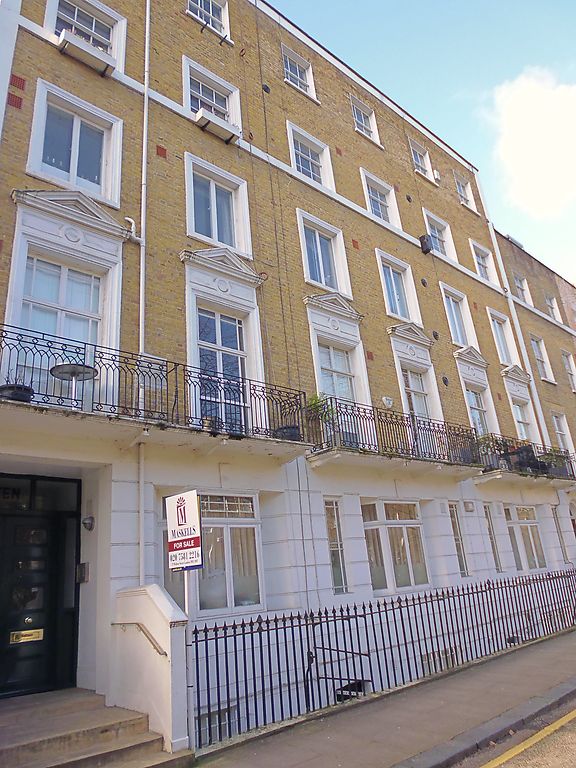
TQ 2779 SW BROMPTON SQUARE SW3
40/10
15.4.69 Nos 10 to 12 (consec)
GV
II
Dwelling houses. 1824-39. Five-storeys. Originally as Nos 3 to 9 but altered and
somewhat spoilt. Stuccoed. Architraves to first, second and third floor windows, with
pediments to first floor. Later bay windows to ground floor. Balconys.
Forms part of Brompton Square layout.
Listing NGR: TQ2720979226
External links are from the relevant listing authority and, where applicable, Wikidata. Wikidata IDs may be related buildings as well as this specific building. If you want to add or update a link, you will need to do so by editing the Wikidata entry.


Other nearby listed buildings