Approximate Location Map
Large Map »
Latitude: 52.7712 / 52°46'16"N
Longitude: -1.124 / 1°7'26"W
OS Eastings: 459196
OS Northings: 319651
OS Grid: SK591196
Mapcode National: GBR 8KX.BN2
Mapcode Global: WHDHR.PLYW
Plus Code: 9C4WQVCG+F9
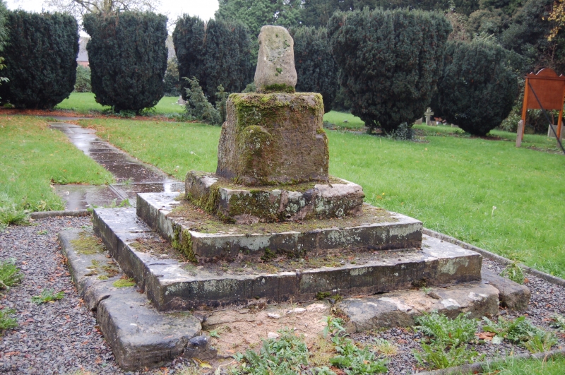
Entry Name: Cross Base in Church Yard, South of Church
Listing Date: 15 March 1984
Grade: II
Source: Historic England
Source ID: 1295295
English Heritage Legacy ID: 189322
ID on this website: 101295295
Location: St Mary's Church, Walton on the Wolds, Charnwood, Leicestershire, LE12
County: Leicestershire
District: Charnwood
Civil Parish: Walton on the Wolds
Traditional County: Leicestershire
Lieutenancy Area (Ceremonial County): Leicestershire
Church of England Parish: Barrow-upon-Soar Holy Trinity
Church of England Diocese: Leicester
Tagged with: Churchyard cross
SK 51 NE WALTON ON THE WOLDS NEW LANE
3/63 Cross base in church
yard, S. of church
GV II
Medieval cross base on 4 stone steps. Square stone base chamfered to
octagon, and stump of shaft.
Listing NGR: SK5919619651
External links are from the relevant listing authority and, where applicable, Wikidata. Wikidata IDs may be related buildings as well as this specific building. If you want to add or update a link, you will need to do so by editing the Wikidata entry.


Other nearby listed buildings
