Approximate Location Map
Large Map »
Latitude: 54.0399 / 54°2'23"N
Longitude: -1.5674 / 1°34'2"W
OS Eastings: 428429
OS Northings: 460520
OS Grid: SE284605
Mapcode National: GBR KPHQ.GK
Mapcode Global: WHC86.WQTB
Plus Code: 9C6W2CQM+X3
Entry Name: Birchwood Farmhouse
Listing Date: 15 March 1966
Last Amended: 18 May 1987
Grade: II
Source: Historic England
Source ID: 1295954
English Heritage Legacy ID: 331588
ID on this website: 101295954
Location: Ripley, North Yorkshire, HG3
County: North Yorkshire
District: Harrogate
Civil Parish: Ripley
Traditional County: Yorkshire
Lieutenancy Area (Ceremonial County): North Yorkshire
Tagged with: Farmhouse
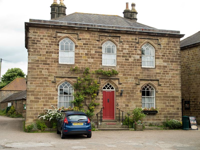
RIPLEY MAIN STREET
SE 2860-2960 (east side)
8/83 Birchwood Farmhouse
(formerly listed as House
15.3.66 to east of and facing
Market Cross)
GV II
Farmhouse. Early-mid C19. Part of the estate village of Sir William
Amcotts Ingilby. Coursed squared gritstone, Westmorland slate roof. 2
storeys, 3 x 2 bays. In Gothick style. Plinth. 3 steps up to central 3-
panel door with interlaced glazing bars to pointed overlight; pointed-arched
door-head with a double chamfer decorated with flower heads in relief; the
chamfers terminating in shields with the Ingilby star in relief at impost
level. All windows have pointed sashes with interlaced glazing bars; the 2-
piece arched lintels have a star motif at impost level as doorway. Square
hoodmoulds to all openings. Moulded eaves cornice and shallow blocking
course; hipped roof with 2 paired octagonal flued corniced stacks to rear,
left and right. Left return: window first floor left as front; blind
windows to right, ground and first floors. Sir William's father, Sir John
(d1815) was responsible for the rebuilding of the Castle. Sir William used
the flower motif, Ingilby star, 2-piece lintel and window form from the
pedestrian entrance to the gatehouse and the windows of the north (coach-
house) range of the Castle for several houses in the village: Horngarth is
identical; Vale Lodge and Castle Close differ only in the chimney position
and Star House and Cottage are similar.
Listing NGR: SE2842960520
External links are from the relevant listing authority and, where applicable, Wikidata. Wikidata IDs may be related buildings as well as this specific building. If you want to add or update a link, you will need to do so by editing the Wikidata entry.


Other nearby listed buildings
