Latitude: 51.3309 / 51°19'51"N
Longitude: -1.2453 / 1°14'43"W
OS Eastings: 452677
OS Northings: 159364
OS Grid: SU526593
Mapcode National: GBR 945.HZ7
Mapcode Global: VHCZS.CTJ2
Plus Code: 9C3W8QJ3+9V
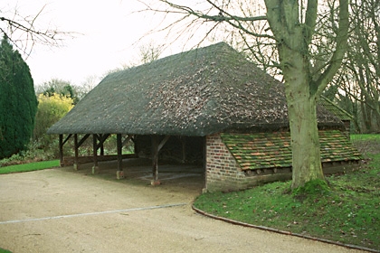
Entry Name: Cartshed Approximately 40 Metres West of Island Millhouse
Listing Date: 18 May 1984
Grade: II
Source: Historic England
Source ID: 1296741
English Heritage Legacy ID: 138260
ID on this website: 101296741
Location: Kingsclere, Basingstoke and Deane, Hampshire, RG20
County: Hampshire
District: Basingstoke and Deane
Civil Parish: Kingsclere
Traditional County: Hampshire
Lieutenancy Area (Ceremonial County): Hampshire
Church of England Parish: Kingsclere
Church of England Diocese: Winchester
Tagged with: Carriage house
SU 55 NW KINGSCLERE UNION LANE
8/22
Cartshed approximately
40 metres west of
Island Millhouse
GV
II
Early C19. Five-bay timber-frame with straight struts to the truss, the rear aisle
having been widened at a later date. Corrugated iron roof. Boarded walling.
Listing NGR: SU5283757840
External links are from the relevant listing authority and, where applicable, Wikidata. Wikidata IDs may be related buildings as well as this specific building. If you want to add or update a link, you will need to do so by editing the Wikidata entry.


Other nearby listed buildings