Approximate Location Map
Large Map »
Latitude: 51.5277 / 51°31'39"N
Longitude: -0.1142 / 0°6'51"W
OS Eastings: 530910
OS Northings: 182664
OS Grid: TQ309826
Mapcode National: GBR L6.HJ
Mapcode Global: VHGQS.YVZQ
Plus Code: 9C3XGVHP+38
Entry Name: Numbers 34-38, 38A and 38B, 39-41 and Attached Railings
Listing Date: 29 September 1972
Last Amended: 30 September 1994
Grade: II
Source: Historic England
Source ID: 1298062
English Heritage Legacy ID: 368923
ID on this website: 101298062
Location: Finsbury, Islington, London, WC1X
County: London
District: Islington
Electoral Ward/Division: Clerkenwell
Parish: Non Civil Parish
Built-Up Area: Islington
Traditional County: Middlesex
Lieutenancy Area (Ceremonial County): Greater London
Church of England Parish: Clerkenwell Holy Redeemer
Church of England Diocese: London
Tagged with: Building
ISLINGTON
TQ3082NE GRANVILLE SQUARE
635-1/67/421 (North West side)
29/09/72 Nos.34-38;38A&38B;39-41
and attached railings
(Formerly Listed as:
GRANVILLE SQUARE
(North West side)
Nos.1-13;22-38B;39-41 (Consecutive))
GV II
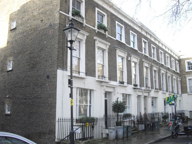
10 terraced houses. In Square planned 1828 by John Booth and
his son, also John, Surveyors for the Lloyd Baker Estate.
Built 1841-1843 by William Joseph Booth, another son,
architect; nos. 27-38B built 1864 by Metropolitan Railway;
buildings essentially dismantled and reconstucted c.1980 by
Islington Council and converted to flats. Yellow stock brick
set in Flemish bond with banded stucco ground-floor to nos.
39-41, stucco lined as ashlar to nos. 34-38B and stucco
dressings; roofs obscured, party-wall brick stacks. Side-hall
entrance plan; no. 41 with stucco side entrance with flanking
pilasters carrying entablature in right return in Granville
Street. Three storeys with basement; 2 windows each and
1-window range to Granville Street elevation. Symmetrical
composition: houses in groups of six; centre and end houses
break forward. Steps rise to entrance: doorway (no. 38A
altered) with panelled pilaster jambs carrying corniced-head,
patterned or plain rectangular overlight and original panelled
door to nos. 34 & 39; others with C20 panelled door. Door to
nos. 35-38 paired and share common console-bracket. 6/6 and
8/8 sashes to nos. 39-41: ground-floor with margin lights;
upper floors architraved and 1st floor stucco sill band to
full-length sashes with cornices and individual balconies with
cast-iron railings. Tripartite pilastered ground-floor sashes
with keystones to nos. 34-38B and 1st-floor cast-iron window
guards to all except nos. 38-38A; predominantly 2/2 sashes to
upper floors of 27-33, some with iron window guards and sill
brackets and all with stucco sill band. Plain stucco band
beneath cornice and blocking course to nos. 39-41; nos. 34-38B
with brick string course and plain brick parapet, some with
iron tie rods. Plain brick left-hand return wall (no. 34)
forms side wall to 'Riceyman Steps' (q.v.). Attached cast-iron
railings with tasselled spearhead finials. Granville Square
was the final portion of the Lloyd Baker Estate to be built;
formerly it had functioned as a rubbish tip by builders of
nearby streets. Originally it was called Sharp Square in
honour of Thomas Lloyd Baker's wife, niece to William
Granville Sharp, Esq, of Fulham. St. Philip's church was built
first, in the centre of the Square, by Edward Buckton Lamb,
architect, in 1831-1833 but it was demolished in 1938. In the
1850s the Metropolitan Railway was built below the Square and
the company purchased and subsequently demolished the whole SW
corner, nos. 29-38, because of subsidence and rebuilt them in
1864. Granville Square is the only street in the Lloyd Baker
Estate that was built in a conventional terrace style and is
notably squeezed into a restricted space between Wharton and
Lloyd Baker Streets. Entrances to Square at north and south
via Granville Street and from west connected to King's Cross
Road by a flight of granite steps known variously as "Plum
Pudding Steps" or "Riceyman Steps".
(The Squares of Islington: Cosh, Mary: The Squares of
Islington Part I: Finsbury and Clerkenwell: Islington: 1990-:
47-51).
Listing NGR: TQ3091082664
External links are from the relevant listing authority and, where applicable, Wikidata. Wikidata IDs may be related buildings as well as this specific building. If you want to add or update a link, you will need to do so by editing the Wikidata entry.


Other nearby listed buildings
