Approximate Location Map
Large Map »
Latitude: 54.5701 / 54°34'12"N
Longitude: -1.5351 / 1°32'6"W
OS Eastings: 430153
OS Northings: 519535
OS Grid: NZ301195
Mapcode National: GBR KHQL.GH
Mapcode Global: WHC5Q.DD79
Plus Code: 9C6WHFC7+3X
Entry Name: U Plan Farmbuildings and Gin Gang North of Peartree House
Listing Date: 27 January 1988
Grade: II
Source: Historic England
Source ID: 1299443
English Heritage Legacy ID: 350385
ID on this website: 101299443
Location: Darlington, County Durham, DL1
County: Darlington
Civil Parish: Brafferton
Traditional County: Durham
Lieutenancy Area (Ceremonial County): County Durham
Church of England Parish: Great Aycliffe
Church of England Diocese: Durham
Tagged with: Architectural structure
BRAFFERTON KETTON LANE
NZ 31 NW (South side, off)
5/14 U-plan farmbuildings
and gin-gang north
of Peartree House
GV II
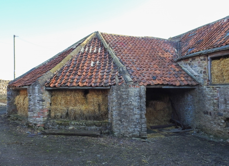
Linked farmbuildings and gin-gang. Late C18-early C19 of several builds.
Coursed and squared limestone; pantiled roofs with stone-flagged eaves. U-plan
ranges enclosing fold yard on 3 sides: central threshing barn and flanking
byres; single-storey ranges at right-angles; gin-gang on rear of barn. 2-storey,
3-bay barn with central Dutch door facing yard and 2 rows of blocked breathers
on front and rear; steeply-pitched roof has raised verges with reverse-stepped
gables. Flanking single-storey, 3-bay byres have opposing doorways and similar
roof/gable details; rebuilt front wall of byre at right has 3 elliptical arches
of brick. Single-storey ranges at right-angles have blocked elliptical arches
on front returns and hipped roofs. Large gin-gang with polygonal end has
rectangular-plan piers and low linking walls; semi-pyramidal roof with stone
ridge tiles. The fold yard is covered by three C20 pitched roofs which are not
of special interest. A well-preserved and relatively unaltered group.
Listing NGR: NZ3015319535
External links are from the relevant listing authority and, where applicable, Wikidata. Wikidata IDs may be related buildings as well as this specific building. If you want to add or update a link, you will need to do so by editing the Wikidata entry.


Other nearby listed buildings
