Approximate Location Map
Large Map »
Latitude: 53.585 / 53°35'5"N
Longitude: -1.7093 / 1°42'33"W
OS Eastings: 419342
OS Northings: 409862
OS Grid: SE193098
Mapcode National: GBR JVHZ.RL
Mapcode Global: WHCBG.Q570
Plus Code: 9C5WH7MR+X7
Entry Name: The Granary
Listing Date: 23 June 1965
Last Amended: 16 May 1984
Grade: II
Source: Historic England
Source ID: 1300344
English Heritage Legacy ID: 341216
ID on this website: 101300344
Location: Shepley, Kirklees, West Yorkshire, HD8
County: Kirklees
Civil Parish: Kirkburton
Built-Up Area: Shepley
Traditional County: Yorkshire
Lieutenancy Area (Ceremonial County): West Yorkshire
Church of England Parish: Shepley St Paul
Church of England Diocese: Leeds
Tagged with: Granary
SE 10 NE
8/101
23rd June 1965
STATION ROAD
Shepley
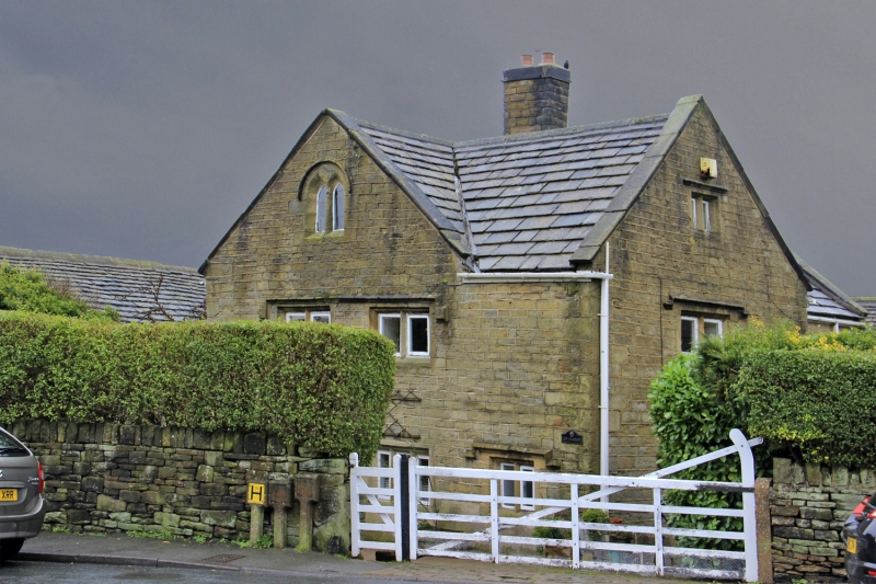
The Granary (formerly listed as Outbuilding at Croft Head Farm, Shepley)
G.V.
II
Detached house, part of group. Early C17 with extensive recent
alterations in keeping. Hammer dressed stone. Quoins. Stone
slate roof with chamfered gable copings. Central ashlar stack
with later top. Two storeys. Projecting gabled wing to left
gives an 'L'-plan. 2- & 3-light double chamfered windows many
of which have been altered or replaced in keeping. Drip-mould
stops have been added. The main entrance with deep lintel and
hood-mould is on the right gable. The windows to the cross wing,
including a cross-window and 2-light window in apex, have been >
altered but hood moulds are original. The left gable has a 2-light
window with pointed arched lights in apex. Rear is rendered.
Interior: The parlour at the right hand end has stop-chamfered beams
and reed-moulded joists, a very wide arched fireplace, and an internal
doorway with arched oak surround and reed-moulding.
Listing NGR: SE1934209862
External links are from the relevant listing authority and, where applicable, Wikidata. Wikidata IDs may be related buildings as well as this specific building. If you want to add or update a link, you will need to do so by editing the Wikidata entry.


Other nearby listed buildings
