Approximate Location Map
Large Map »
Latitude: 53.8725 / 53°52'20"N
Longitude: -1.8653 / 1°51'54"W
OS Eastings: 408955
OS Northings: 441816
OS Grid: SE089418
Mapcode National: GBR HRDN.ZK
Mapcode Global: WHC8V.BX0N
Plus Code: 9C5WV4CM+XV
Entry Name: Swine Lane Bridge
Listing Date: 4 December 1986
Grade: II
Source: Historic England
Source ID: 1300630
English Heritage Legacy ID: 338373
ID on this website: 101300630
Location: East Morton, Bradford, West Yorkshire, BD20
County: Bradford
Civil Parish: Keighley
Built-Up Area: Keighley
Traditional County: Yorkshire
Lieutenancy Area (Ceremonial County): West Yorkshire
Church of England Parish: Morton St Luke
Church of England Diocese: Leeds
Tagged with: Bridge
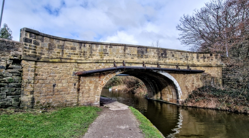
KEIGHLEY SWINE LANE
SE 04 SE Riddlesden
5/267
Swine Lane Bridge
- II
Canal bridge. 1770s. Stone. Single, round arch with pilasters, rusticated
voussoirs, string course and plain parapet. Spans the Leeds and Liverpool Canal,
this section of which was opened in 1733.
Listing NGR: SE0895541816
External links are from the relevant listing authority and, where applicable, Wikidata. Wikidata IDs may be related buildings as well as this specific building. If you want to add or update a link, you will need to do so by editing the Wikidata entry.


Other nearby listed buildings
