Latitude: 54.4576 / 54°27'27"N
Longitude: -1.731 / 1°43'51"W
OS Eastings: 417536
OS Northings: 506944
OS Grid: NZ175069
Mapcode National: GBR JJCW.1V
Mapcode Global: WHC66.C7Y2
Plus Code: 9C6WF759+2H
Entry Name: Blackhill Folly
Listing Date: 4 February 1969
Last Amended: 21 May 1987
Grade: II
Source: Historic England
Source ID: 1301408
English Heritage Legacy ID: 323272
ID on this website: 101301408
Location: Hartforth, North Yorkshire, DL10
County: North Yorkshire
District: Richmondshire
Town: Richmondshire
Civil Parish: Gilling with Hartforth and Sedbury
Traditional County: Yorkshire
Lieutenancy Area (Ceremonial County): North Yorkshire
Church of England Parish: Gilling St Agatha
Church of England Diocese: Leeds
Tagged with: Architectural structure
This list entry was subject to a Minor Amendment on 25 September 2025 to correct a typo in the description and to reformat the text to current standards
NZ 10 NE
6/60
GILLING WITH HARTFORTH AND SEDBURY
FORCETT LANE (west side, off)
Blackhill Folly
(formerly listed as Agricultural buildings south-east of Blackhill Farmhouse)
4.2.69
II
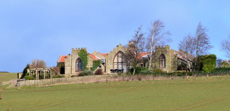
Fold yard for cattle. Late C18 - early C19. Probably by John Foss of Richmond for the Cradock family of Hartforth Hall (qv). Rubble, coursed to south, pantile roofs. Single-storey ranges arranged around a courtyard, with screen wall forming fourth side. Screen wall, south side: three gables joined by plain walls. Each gable projects slightly, is quoined, contains a recessed rendered blind pointed opening flanked by rendered blind loop-holes, and has crenellation. Centre gable has tall, wide, blind opening and gabled crenellation with flat profile. Outer gables have narrow central quoined projections with window-like blind openings and sloping crenellation. East and west ranges have access openings towards north end and board doors and slit vents onto yard. North range taller and with three semicircular arched openings. King-post roof trusses in west range, queen- strut roof trusses in east range.
Listing NGR: NZ1753606944
External links are from the relevant listing authority and, where applicable, Wikidata. Wikidata IDs may be related buildings as well as this specific building. If you want to add or update a link, you will need to do so by editing the Wikidata entry.


Other nearby listed buildings