Approximate Location Map
Large Map »
Latitude: 52.1363 / 52°8'10"N
Longitude: -2.2159 / 2°12'57"W
OS Eastings: 385322
OS Northings: 248693
OS Grid: SO853486
Mapcode National: GBR 1GX.4KQ
Mapcode Global: VH930.JKXM
Plus Code: 9C4V4QPM+GM
Entry Name: 35, Main Road
Listing Date: 9 February 1988
Grade: II
Source: Historic England
Source ID: 1301498
English Heritage Legacy ID: 153337
ID on this website: 101301498
Location: Kempsey, Malvern Hills, Worcestershire, WR5
County: Worcestershire
District: Malvern Hills
Civil Parish: Kempsey
Built-Up Area: Kempsey
Traditional County: Worcestershire
Lieutenancy Area (Ceremonial County): Worcestershire
Church of England Parish: The baptist
Church of England Diocese: Worcester
Tagged with: Architectural structure
This list entry was subject to a Minor Amendment on 09/09/2020
SO 8448-8548
10/24
KEMPSEY CP
MAIN ROAD
No 35
(Formerly listed as No 35 (West Royd Stores), WORCESTER ROAD (west side)
II
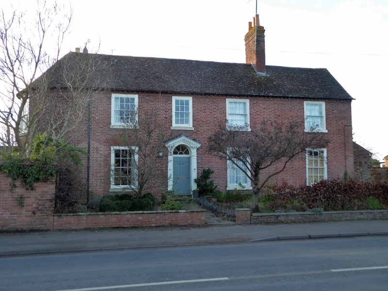
House. Circa 1800. Brick in Flemish bond with tile roof. Two storeys, four bays. Windows sashed with glazing bars. Left-hand window on ground floor replaced by C20 plate glass. Ground floor windows have gauged brick heads. C20 doorway inserted at left. The doorway in the second bay has a round head with fanlight and a Tuscan pilaster doorcase with open pediment. Brick dentil course at eaves. Chimney between third and fourth bays. The left-hand return wall of the front range, facing south, is curved, and of two bays. It has sashed windows with glazing bars. Set back to its left is the south wall of a rear wing, also of two bays.
Listing NGR: SO8532248693
External links are from the relevant listing authority and, where applicable, Wikidata. Wikidata IDs may be related buildings as well as this specific building. If you want to add or update a link, you will need to do so by editing the Wikidata entry.


Other nearby listed buildings
