Approximate Location Map
Large Map »
Latitude: 51.0857 / 51°5'8"N
Longitude: -1.0105 / 1°0'37"W
OS Eastings: 469404
OS Northings: 132291
OS Grid: SU694322
Mapcode National: GBR B8Q.WXV
Mapcode Global: FRA 86S7.S7L
Plus Code: 9C3W3XPQ+7R
Entry Name: Stable Block South West of the House
Listing Date: 18 July 1986
Grade: II
Source: Historic England
Source ID: 1301632
English Heritage Legacy ID: 142968
ID on this website: 101301632
Location: East Hampshire, GU34
County: Hampshire
District: East Hampshire
Civil Parish: East Tisted
Traditional County: Hampshire
Lieutenancy Area (Ceremonial County): Hampshire
Church of England Parish: East Tisted with Colemore St James
Church of England Diocese: Winchester
Tagged with: Stable
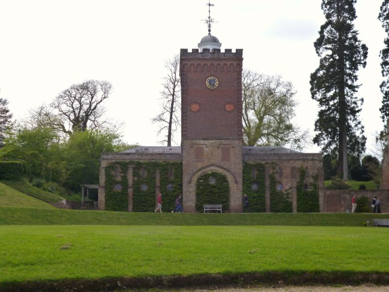
EAST TISTED ROTHERFIELD PARK
SU 63 SE
4/2 Stable Block south west
of the House
GV II
Stables and coachhouse, now garage and stores. Early and mid C19. Brick and
slate. Plain buildings on 3 sides of a courtyard, with a more ornamental
treatment of the (outer) east elevation, seen with the west range of the house.
A central tower with cupola, above a carriage archway, flanked by wings of 3
bays; this general form can be discerned in a perspective sketch of the
original scheme by Joseph Parkinson, but the tower was raised in the late C19,
apparently re-using the cupola. East elevation: symmetrical. The tall tower
has an octagonal arcaded cupola with an ogee cap, and a crenellated and
machicolated parapet,walls of Flemish bond with blue headers, a band (original
parapet base?) above 2 small windows with hood moulds (now filled), and a
carriage arch of Tudor form, with hood mould and deep splay. Low pitched
hipped roof, continuing at a lower level above the other 2 ranges, one with
malmstone walls (of the original building?). On each side there are small
lancets within deep splays, separated by slender stepped buttresses. Interior:
the stalls remain, the large central arch being open to the courtyard but filled
at the outer face. The building marks the south end of a group of towers, which
dominate the unusual skyline of Rotherfield Park, as seen from the east.
External links are from the relevant listing authority and, where applicable, Wikidata. Wikidata IDs may be related buildings as well as this specific building. If you want to add or update a link, you will need to do so by editing the Wikidata entry.


Other nearby listed buildings
