Approximate Location Map
Large Map »
Latitude: 54.392 / 54°23'31"N
Longitude: -1.6652 / 1°39'54"W
OS Eastings: 421836
OS Northings: 499662
OS Grid: SE218996
Mapcode National: GBR JKTN.8C
Mapcode Global: WHC6F.DV8X
Plus Code: 9C6W98RM+QW
Entry Name: Inglenook
Listing Date: 4 February 1969
Last Amended: 6 November 1986
Grade: II
Source: Historic England
Source ID: 1301932
English Heritage Legacy ID: 322078
ID on this website: 101301932
Location: Brompton-on-Swale, North Yorkshire, DL10
County: North Yorkshire
District: Richmondshire
Civil Parish: Brompton-on-Swale
Built-Up Area: Brompton-on-Swale
Traditional County: Yorkshire
Lieutenancy Area (Ceremonial County): North Yorkshire
Church of England Parish: Easby with Brompton on Swale and Bolton on Swale
Church of England Diocese: Leeds
Tagged with: Building
BROMPTON-ON-SWALE RICHMOND ROAD
SE 2099-2199 (south side)
11/12 No 15 (Inglenook)
(formerly listed as
4.2.69 Inglenook, Front Street)
GV II
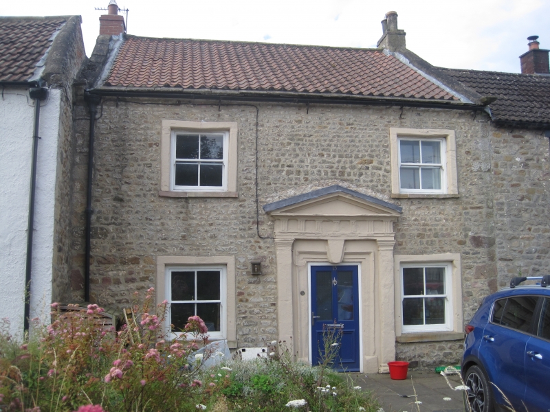
House. c1733, possibly earlier in origin. Coursed rubble, pantile roof
with course of stone slates at eaves. 2 storeys, 2 first-floor windows.
Quoins. Central part-glazed 4-panel door in ashlar architrave with
tripartite keystone within ashlar pedimented door-case with Roman Doric
pilasters and triglyphs to frieze. 4-pane sash windows in plain ashlar
surrounds. Shaped kneelers, ashlar copings. Brick end stacks. Interior:
in ground-floor room to left, inglenook fireplace with spere to right, salt-
box in recess to left with fielded-panel door and butterfly hinges. Stop-
chamfered beams. Splat-baluster staircase with decorated plaster ceiling to
stairwell, with circular panel and dentilled cornice with acanthus motif.
Doors of 3 fielded panels on first-floor landing. In first-floor left front
room, staircase to roof-space winds tightly round in recess to left of
chimney-stack. The deeds of the house go back to 1733, which date fits the
facade well, but the building may be older. It is said to have been once an
inn, and there is a small cellar below the staircase, and unusually wide
doors in the passage leading from behind the spere to the back kitchen. One
internal door had "Taproom" painted on it. There is a well in the garden.
There is a local tradition that the unusually elaborate door-case was
retrieved from the extensive Roman settlement of Catteractonium, very close
by.
Listing NGR: SE2183699662
External links are from the relevant listing authority and, where applicable, Wikidata. Wikidata IDs may be related buildings as well as this specific building. If you want to add or update a link, you will need to do so by editing the Wikidata entry.


Other nearby listed buildings
