Latitude: 51.7795 / 51°46'46"N
Longitude: -2.1148 / 2°6'53"W
OS Eastings: 392176
OS Northings: 208988
OS Grid: SO921089
Mapcode National: GBR 2NN.D4D
Mapcode Global: VH94T.9JBP
Plus Code: 9C3VQVHP+R3
Entry Name: Honeycombe Farmhouse
Listing Date: 28 June 1960
Grade: II
Source: Historic England
Source ID: 1302975
English Heritage Legacy ID: 132716
ID on this website: 101302975
Location: Wishanger, Stroud, Gloucestershire, GL6
County: Gloucestershire
District: Stroud
Civil Parish: Miserden
Traditional County: Gloucestershire
Lieutenancy Area (Ceremonial County): Gloucestershire
Church of England Parish: Miserden St Andrew
Church of England Diocese: Gloucester
Tagged with: Farmhouse
SO 90 NW MISERDEN -
5/157 Honeycombe Farmhouse
28.6.60
GV II
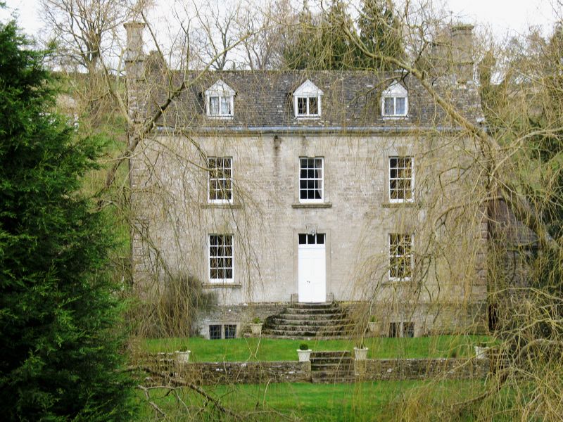
Detached farmhouse. Early C17; extensive rebuilding and
enlargement c1730. Random rubble limestone, coursed and squared to
east front; ashlar chimneys; stone slate and concrete tile roof.
Double-pile plan; 2-storey with cellar and attic. East front: 3-
window fenestration, all 12-pane sashes with triple-keyed beaded
architraves and bull-nosed sills. Similar opening to central
doorway with double 3-panel fielded doors, reached up flight of
round-fronted stone steps. Rubble plinth; two 2-light chamfered
mullioned cellar casements. Alternating chamfered quoins; moulded
eaves cornice. Three pedimented roof dormers with leaded timber
casements. Ends: 2 parapet gables, each front range gable having
chimney with moulded cap. Single-window 12-pane sash fenestration
with keyed architraves to ends of rear range. North end has round-
ended bread oven projection and C17 keyed round-arched doorway.
Rear: central parapet gable with sash window to each upper floor
centrally below, that to upper floor being round-arched with
keystone and imposts. Short row of pigeon holes below eaves to
left. Two eaves-mounted chimneys with moulded caps.
Interior: dog-leg staircase with moulded and ramped handrail, 2
turned balusters per tread. Stone vaulted cellar to front and rear
ranges. Barn to north (q.v.) and stable to north east (q.v.).
(D. Verey, Gloucestershire: The Cotswolds, 1979)
Listing NGR: SO9217608988
External links are from the relevant listing authority and, where applicable, Wikidata. Wikidata IDs may be related buildings as well as this specific building. If you want to add or update a link, you will need to do so by editing the Wikidata entry.


Other nearby listed buildings