Approximate Location Map
Large Map »
Latitude: 51.3751 / 51°22'30"N
Longitude: -1.1745 / 1°10'28"W
OS Eastings: 457552
OS Northings: 164330
OS Grid: SU575643
Mapcode National: GBR 93P.PW4
Mapcode Global: VHCZM.LPFP
Plus Code: 9C3W9RGG+25
Entry Name: Granary Approximately 150 Metres to West of Wasing Place
Listing Date: 6 April 1967
Grade: II
Source: Historic England
Source ID: 1303090
English Heritage Legacy ID: 39664
ID on this website: 101303090
Location: Wasing, West Berkshire, RG7
County: West Berkshire
Civil Parish: Wasing
Traditional County: Berkshire
Lieutenancy Area (Ceremonial County): Berkshire
Church of England Parish: Aldermaston
Church of England Diocese: Oxford
Tagged with: Granary
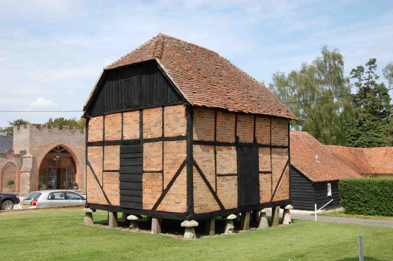
WASING WASING PARK
SU 56SE
6/13 Granary Approximately 150
6.4.67 Metres To West Of
Wasing Place
GV II
Granart. C18. Timber framed with brick nogging, matchboarded gables to north and
south to old tile half hipped roof. Rectangular plan on 12 staddlestones. 1 1/2
storeys. Loft window to north. Boarded doors to north, east and south.
Listing NGR: SU5755464332
External links are from the relevant listing authority and, where applicable, Wikidata. Wikidata IDs may be related buildings as well as this specific building. If you want to add or update a link, you will need to do so by editing the Wikidata entry.


Other nearby listed buildings
