Latitude: 51.4034 / 51°24'12"N
Longitude: -1.2572 / 1°15'25"W
OS Eastings: 451769
OS Northings: 167411
OS Grid: SU517674
Mapcode National: GBR 936.T65
Mapcode Global: VHCZD.5Z7K
Plus Code: 9C3WCP3V+84
Entry Name: The Kings Head Inn
Listing Date: 10 November 1983
Grade: II
Source: Historic England
Source ID: 1303187
English Heritage Legacy ID: 39616
ID on this website: 101303187
Location: Thatcham, West Berkshire, RG19
County: West Berkshire
Civil Parish: Thatcham
Built-Up Area: Thatcham
Traditional County: Berkshire
Lieutenancy Area (Ceremonial County): Berkshire
Church of England Parish: Thatcham
Church of England Diocese: Oxford
Tagged with: Inn
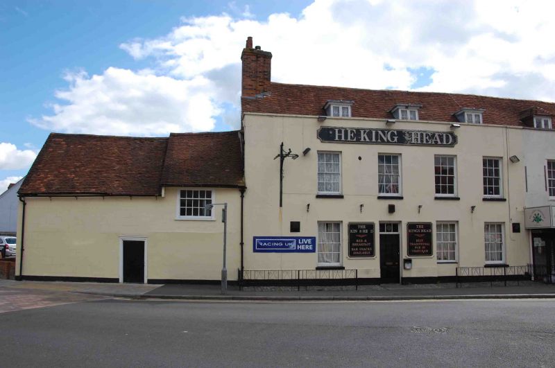
THATCHAM THE BROADWAY (east side)
SU 5167
8/14 No. 59
(The Kings Head Inn)
GV II
Inn. C18. Rendered; incised to represent ashlar, coped parapet and old tile roof
with end stack to left. 3 dormers with casements. 2 storeys; 4 bays, glazing bar
sashes. Half glazed door in second bay from left. One storey rendered and tiled
addition to left with boarded door and one glazing bar sash.
Listing NGR: SU5177467404
External links are from the relevant listing authority and, where applicable, Wikidata. Wikidata IDs may be related buildings as well as this specific building. If you want to add or update a link, you will need to do so by editing the Wikidata entry.


Other nearby listed buildings