Approximate Location Map
Large Map »
Latitude: 51.4103 / 51°24'36"N
Longitude: -0.8337 / 0°50'1"W
OS Eastings: 481211
OS Northings: 168561
OS Grid: SU812685
Mapcode National: GBR D7R.D1W
Mapcode Global: VHDX2.HTM8
Plus Code: 9C3XC568+4G
Entry Name: The Town Hall
Listing Date: 2 October 1969
Last Amended: 10 April 2003
Grade: II*
Source: Historic England
Source ID: 1303481
English Heritage Legacy ID: 41682
ID on this website: 101303481
Location: Wokingham, Berkshire, RG40
County: Wokingham
Civil Parish: Wokingham
Built-Up Area: Wokingham
Traditional County: Berkshire
Lieutenancy Area (Ceremonial County): Berkshire
Church of England Parish: Wokingham
Church of England Diocese: Oxford
Tagged with: City hall Seat of local government
SU 8168 NW
18/26
WOKINGHAM
MARKET PLACE
The Town Hall
2.10.69
G.V.
II*
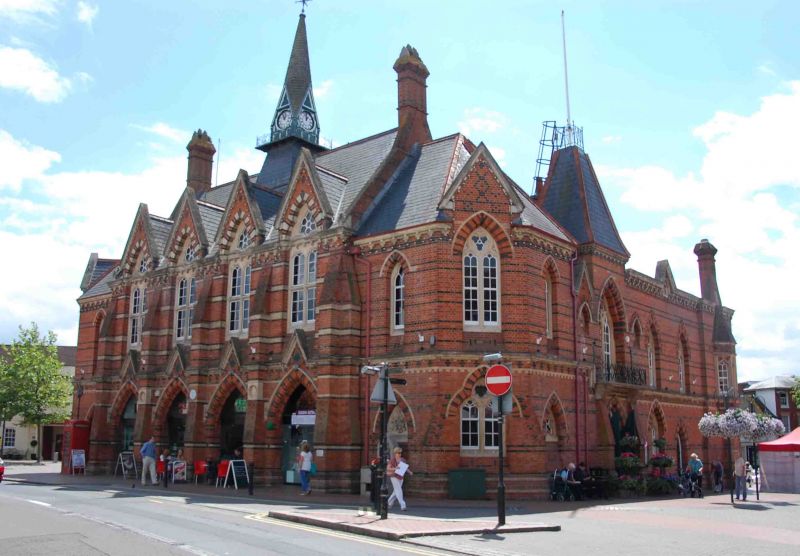
Town hall and police station, later also fire station; now town hall and offices, with four shops and enclosed market. 1860 with minor late-C20 alterations. (William Ford) Poulton (1822-1900) and (William Henry) Woodman (1822-1879). Wheeler and Woodroffe, craftsmen. High Victorian Free Gothic style. Red brick, with blue brick and Bath stone dressings used to polychromatic effect. Steeply pitched slate roofs. Brick corbelled chimneys.
PLAN: Triangular plan on island site with two-storey-plus-attic main range to north, lower wings extending to the south on each side and continuing to wide one-storey apse that encloses the rear yard. Main range with hall, council chamber and ancillary rooms to first floor, and four shops at ground floor.
EXTERIORS: Irregular facades with projecting moulded plinth, buttresses, dentilled and moulded string course at first floor cill level, dentilled and moulded eaves course and parapet cornice and coped gables. Most windows trefoil headed lancets with stone surrounds, mullions and transoms under polychrome pointed arches. NORTH elevation with central section of four bays defined by full height buttresses with moulded bases and splayed tops. Each bay with large pointed arched openings to ground floor, now with late-C20 plain glass shop windows, pointed relieving arches in tympanum, first floor large cross windows under seven-light window in trefoil stone surround, all under steep gable with stone copings. Steep pitched roof with two tall corbelled chimneys and central tall fleche with 'Tucker of London' clock movement, weathercock, and iron balustraded platform. Lower apsidal ends to east and west with hipped roof and steep gable above three-light windows to ground and first floors. EAST and WEST elevations both have entrance bay at north end with double doors under pointed arch, tall three-light window at first floor with iron balcony, and steep 'Chateau' style roof. WEST elevation with secondary entrance and window to ground floor Mayor's chamber, pair of windows above and stone 'County Police Station' plaque to centre under gablet with stone coping. Elaborate oriel to south end has three lancets with stone ogee arches. SOUTH elevation with wide one-storey 'apse' with central wide opening under steep pointed gable, deep 'X' pattern brick frieze, and view to the numerous chimneys, gables and fleche of the higher ranges.
INTERIOR: Main range has first floor hall of four bays with elaborate chamfered hammer-beam truss roof with carved stone corbel blocks and shields painted with coats-of-arms of past and present High Stewards of Wokingham. Wide carved stone fireplace to centre of west wall. Smaller stone fireplace in outside wall to northeast corner. At east end, a tall pointed arch with wooden panelled sliding doors to War Memorial room, with wooden carved and moulded memorial on east wall and stone fireplace in corner. At west end, a small council chamber with a band of wooden panelling carved with names of past mayors. Corridor running east-west along the hall to balconies at opposite ends. Town council office with oriel window and fireplace. Mayor's parlour at ground floor in former police superintendent's chamber. Two prison cells with barred iron doors and locks.
HISTORY: The Town Hall stands on the site of the Medieval Guildhall, which was demolished in 1858. The new Town Hall was opened on June 6, 1860 by Lord Braybrooke. It was funded in part by money available for a new County Police Station, and the building jointly housed the police until 1905 when the new police station was built. Two of the original three prison cells survive. In 1877, the Fire Brigade housed a horse-drawn fire engine in the covered market, and this use continued until 1969 when the fire station was built. The building also housed a covered market under the arches, which are now used as individual shops.
Group value with the listed buildings around the perimeter of the site and the dated 1881 Drinking Fountain (q.v.) and K6 Telephone Kiosk (q.v.) immediately adjacent to the Town Hall.
Listing NGR: SU8121168561
This List entry has been amended to add sources for War Memorials Online and the War Memorials Register. These sources were not used in the compilation of this List entry but are added here as a guide for further reading, 25 October 2017.
External links are from the relevant listing authority and, where applicable, Wikidata. Wikidata IDs may be related buildings as well as this specific building. If you want to add or update a link, you will need to do so by editing the Wikidata entry.


Other nearby listed buildings
