Latitude: 51.4537 / 51°27'13"N
Longitude: -0.9737 / 0°58'25"W
OS Eastings: 471408
OS Northings: 173244
OS Grid: SU714732
Mapcode National: GBR QLG.CB
Mapcode Global: VHDWT.2QLG
Plus Code: 9C3XF23G+FG
Entry Name: 2 and 4 Bridge Street
Listing Date: 22 June 1977
Last Amended: 14 March 2024
Grade: II
Source: Historic England
Source ID: 1303747
English Heritage Legacy ID: 38771
ID on this website: 101303747
Location: Reading, Berkshire, RG1
County: Reading
Electoral Ward/Division: Abbey
Parish: Non Civil Parish
Built-Up Area: Reading
Traditional County: Berkshire
Lieutenancy Area (Ceremonial County): Berkshire
Church of England Parish: Reading St Giles
Church of England Diocese: Oxford
Tagged with: Building
House or houses constructed in the early C19, partially converted to commercial use by 1909.
House or houses, later in commercial use, constructed in the early C19.
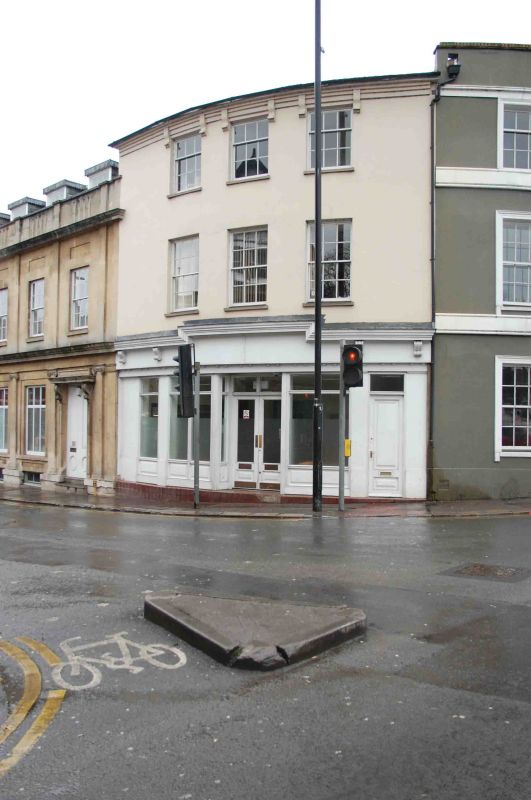
MATERIALS: the street elevation is stuccoed on the first and second floors and has a timber shop front on the ground floor. The roof covering is slate to the eastern roof slope and lead to the western slope. Windows are timber.
PLAN: the building occupies a quadrant-shaped plot, with a curved street frontage to the north-east.
EXTERIOR: the building is of three storeys under a pitched roof shared with the adjoining property at 1 Castle Street. The ground floor shopfront comprises a recessed, central doorway flanked by fixed windows with raised and fielded stallrisers, and a separate entrance to the upper floors on the northernmost end of the elevation. Above, the fascia board is carried on a series of paired dentils and has a heavy cornice with a stepped central section, supported at either end by pairs of modillion brackets.
The first and second floors each have a range of three windows, evenly spaced but set in from either end of the elevation. Those at the first floor are six-over-six timber sashes and those on the second floor are three-over-six sashes. Flanking each of the second-floor windows are moulded brackets rising to a corbelled, stucco cornice.
2 and 4 Bridge Street was constructed during the early C19, probably on the site of an earlier building. It may have been built at the same time as 1 Castle Street adjoining to the west, although changes to the façades of the two properties make them now appear as distinct buildings from the street. Most likely built as a private residence, the building was at least partly in commercial use by the early 1900s.
The building is now (2023) understood to have been internally combined with 6-10 Bridge Street to the south.
2 and 4 Bridge Street stands on the south-west corner of the crossroads formed by the north-south route of St Mary’s Butts/Bridge Street and the east-west route of Gun Street/Castle Street. This is believed to be the centre of the original Saxon settlement at Reading, established sometime before the ninth century. St Mary’s Church, which lies on the north-east corner of the crossroads, was the town’s primary church until the establishment of Reading Abbey in the C12 and became so again following the dissolution in the late 1530s.
Castle Street forms part of the ancient route through the town between London and the West Country and historically contained many inns and guesthouses. As Reading expanded beyond its medieval limits during the C18 and C19 earlier buildings were gradually replaced with substantial townhouses and public buildings. The redevelopment was piecemeal and mostly confined to individual plots, leading to the street’s great architectural diversity. This pattern was broken in the late 1960s and 1970s, with the construction of the expansive civic complex on the north side of Castle Street, and of the Inner Relief Road immediately to the west of the new complex.
2 and 4 Bridge Street is listed at Grade II for the following principal reasons:
Architectural interest:
* as an early-C19 building, the fabric of which contributes to Reading’s rich and varied architectural character.
Historic interest:
* as part of the later urban development of Reading’s ancient core.
Group value:
* the building is in close proximity to a number of listed buildings and contributes to a strong historic streetscape.
External links are from the relevant listing authority and, where applicable, Wikidata. Wikidata IDs may be related buildings as well as this specific building. If you want to add or update a link, you will need to do so by editing the Wikidata entry.


Other nearby listed buildings