Approximate Location Map
Large Map »
Latitude: 51.916 / 51°54'57"N
Longitude: -2.0487 / 2°2'55"W
OS Eastings: 396743
OS Northings: 224168
OS Grid: SO967241
Mapcode National: GBR 2LZ.YMP
Mapcode Global: VHB1Q.F3RH
Plus Code: 9C3VWX82+CG
Entry Name: Home Farmhouse and Attached Stableblock
Listing Date: 4 July 1960
Grade: II
Source: Historic England
Source ID: 1304134
English Heritage Legacy ID: 134502
ID on this website: 101304134
Location: Prestbury, Cheltenham, Gloucestershire, GL52
County: Gloucestershire
District: Cheltenham
Town: Cheltenham
Civil Parish: Prestbury
Built-Up Area: Cheltenham
Traditional County: Gloucestershire
Lieutenancy Area (Ceremonial County): Gloucestershire
Church of England Parish: Prestbury St Mary
Church of England Diocese: Gloucester
Tagged with: Farmhouse
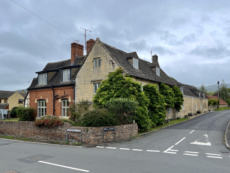
SO 9624 PRESTBURY MILL STREET
(south side)
17/94 Home Farmhouse and attached
stableblock
4.7.60
GV II
Farmhouse. Late C17-mid C18 and mid-late C19. Main body coursed
squared and dressed limestone with a stone slate roof and grey
brick stack on roof pitch facing Mill Street; concrete tile at
rear. Cl9 extension; red brick and coursed squared and dressed
limestone with a concrete tile roof and red brick stacks. Stables;
coursed squared and dressed limestone with a concrete tile roof.
Rectangular plan to main body with C19 extension at right angles
rear left. Late C18-early C19 stable block at right gable end of
main body. Slate roofed lean-to at rear of main body not of
special interest. Main body; two storeys and attic lit by two
late C20 roof dormers. Symmetrical, 3-windowed facade with 2 and 3-
light metal casements with horizontal glazing bars. Two-light
stone-mullioned casements at centre of first floor. Band between
floors continued around left gable end. Central C20 plank door
with pilasters with imposts either side. Projecting bread oven in
the form of a shallow lean-to like projection towards the right
gable end. Two-light casements in left gable end, stopped hood
over first floor windows, garret light with stone mullion. Mid-
late c19 extension facing Bowbridge Lane; 1½ storeys with 2 raking
roof dormers. One 2-light and one 3-light casement to ground floor
both with transoms and within segmental-headed surrounds
incorporating some dressed limestone. Incised foliate carving on
boards filling in segments above each window. Stable (facing
farmyard); single-storey and loft. Segmental-headed doorways and
windows. Single C20 casement in side facing onto Mill Street.
Stack at right gable end of main body. Flat coping and roll-cross
saddle at left gable end. Axial stacks to extension at rear.
Interior not inspected.
Listing NGR: SO9674324168
External links are from the relevant listing authority and, where applicable, Wikidata. Wikidata IDs may be related buildings as well as this specific building. If you want to add or update a link, you will need to do so by editing the Wikidata entry.


Other nearby listed buildings
