Latitude: 51.5861 / 51°35'9"N
Longitude: -2.2574 / 2°15'26"W
OS Eastings: 382262
OS Northings: 187501
OS Grid: ST822875
Mapcode National: GBR 1PG.D3Z
Mapcode Global: VH95P.TDGG
Plus Code: 9C3VHPPV+C2
Entry Name: St Lawrence's Well with Adjacent Drinking Trough and Pump, in Front of Kingsmead House
Listing Date: 16 March 1987
Grade: II
Source: Historic England
Source ID: 1304331
English Heritage Legacy ID: 130384
ID on this website: 101304331
Location: Didmarton, Cotswold, Gloucestershire, GL9
County: Gloucestershire
District: Cotswold
Civil Parish: Didmarton
Built-Up Area: Didmarton
Traditional County: Gloucestershire
Lieutenancy Area (Ceremonial County): Gloucestershire
Church of England Parish: Didmarton St Lawrence
Church of England Diocese: Gloucester
Tagged with: Architectural structure
DIDMARTON THE STREET ST 8287 (north side) 15/70 St. Lawrence's Well with adjacent drinking trough and pump, in front of Kingsmead House GV II
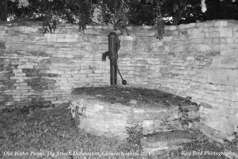
Well, animal drinking trough and water pump, in recessed section of garden wall of Kingsmead House, open to The Street. Well traditionally blessed by St. Lawrence c600, trough and pump of C19. Piece of land with grass to front about 17m in length, with well, trough and pump to rear against dry rubble stone wall with some vermiculated stone to top. Pump to right in iron raised up on filled-in basin, up one step, with working handle and oval plate on stem lettered "J FLETCHER / PLUMBER / YATE'. To left of pump and right of centre in recess of wall is animal trough made of single hollowed-out stone about 2.8m long with tooled front edge, and with built up step to left containing end of circular pipe. To far left in horseshoe-shaped recess of wall is the well, a spring thought never to have frozen nor dried up, originally probably approached by a series of flat stones now partly displaced and with level access from the grass on the left but still with some steps to right with 3 large stones placed vertically in front and along rear wall in line. These 3 closely grouped items form an important feature in the village, both historically and visually.
Listing NGR: ST8226187500
External links are from the relevant listing authority and, where applicable, Wikidata. Wikidata IDs may be related buildings as well as this specific building. If you want to add or update a link, you will need to do so by editing the Wikidata entry.


Other nearby listed buildings