Approximate Location Map
Large Map »
Latitude: 51.8518 / 51°51'6"N
Longitude: -1.7172 / 1°43'1"W
OS Eastings: 419575
OS Northings: 217055
OS Grid: SP195170
Mapcode National: GBR 4QV.YFD
Mapcode Global: VHBZK.6Q19
Plus Code: 9C3WV72M+P4
Entry Name: Stableblock Circa 15 Metres East of Barn, Manor Farmhouse
Listing Date: 28 May 1987
Grade: II
Source: Historic England
Source ID: 1304611
English Heritage Legacy ID: 130877
ID on this website: 101304611
Location: Great Rissington, Cotswold, Gloucestershire, GL54
County: Gloucestershire
District: Cotswold
Civil Parish: Great Rissington
Built-Up Area: Great Rissington
Traditional County: Gloucestershire
Lieutenancy Area (Ceremonial County): Gloucestershire
Church of England Parish: Great Rissington St John the Baptist
Church of England Diocese: Gloucester
Tagged with: Agricultural structure
GREAT RISSINGTON GREAT RISSINGTON VILLAGE
SP 1917-2017
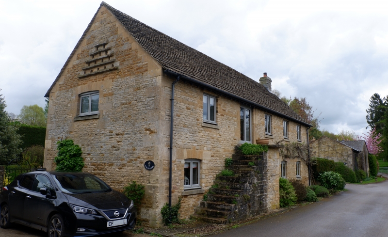
Stable block c15m east of barn,
9/144 Manor Farmhouse
GV II
Stableblock. Early C19. Coursed squared and dressed limestone
with dressed stone quoins. Corrugated felt roofing at front,
concrete tile at rear. Rectangular plan. Lean-to with corrugated
iron roof, at rear, not of special interest. Two storeys; three
2-light cambered-headed windows, two with elongated keystones.
Central plank door with a cambered headed surround and keystone.
Stone steps to left of the door giving access to door to loft. Two
2-light casements to the first floor. Pitching door (now removed)
within a cambered-headed surround in the left gable end.
Triangular arrangement of pigeon holes and landings above.
Ventilation/owl holes towards the apexes of both gable ends.
Interior: first floor removed.
Listing NGR: SP1957517055
External links are from the relevant listing authority and, where applicable, Wikidata. Wikidata IDs may be related buildings as well as this specific building. If you want to add or update a link, you will need to do so by editing the Wikidata entry.


Other nearby listed buildings
