Latitude: 52.8031 / 52°48'11"N
Longitude: 1.4177 / 1°25'3"E
OS Eastings: 630474
OS Northings: 328313
OS Grid: TG304283
Mapcode National: GBR WFS.C80
Mapcode Global: WHMSQ.RS9Y
Plus Code: 9F43RC39+63
Entry Name: Baptist Church
Listing Date: 29 April 1987
Grade: II
Source: Historic England
Source ID: 1304692
English Heritage Legacy ID: 224204
ID on this website: 101304692
Location: Worstead Baptist Church, Meeting House Hill, North Norfolk, NR28
County: Norfolk
District: North Norfolk
Civil Parish: Worstead
Traditional County: Norfolk
Lieutenancy Area (Ceremonial County): Norfolk
Church of England Parish: Worstead St Mary
Church of England Diocese: Norwich
Tagged with: Protestant church building
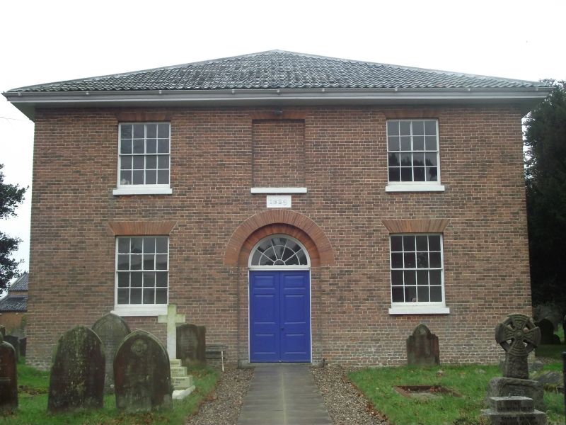
WORSTEAD MEETING HOUSE HILL
TG 32 NW
5/58 Baptist Church
- II
Church. Dated 1829. Brick, hipped roof of black glazed pantiles. Square
ground-plan with 2 storey extension to rear. Facade of 3 bays, 2 storeys.
Central doorway with double reveal, semi-circular gauged brick arch. Double
doors of 3 raised and fielded panels; semi-circular fanlight over, with
radial glazing bars. Sash windows with glazing bars. Interior. Raked
gallery with some box-pews on 3 sides supported on iron pillars. Wine-glass
pulpit with niche behind. To each side of pulpit a large arched opening,
blocked when school-room added.
Listing NGR: TG3047428313
External links are from the relevant listing authority and, where applicable, Wikidata. Wikidata IDs may be related buildings as well as this specific building. If you want to add or update a link, you will need to do so by editing the Wikidata entry.


Other nearby listed buildings