Latitude: 51.7087 / 51°42'31"N
Longitude: -1.7815 / 1°46'53"W
OS Eastings: 415193
OS Northings: 201131
OS Grid: SP151011
Mapcode National: GBR 4SJ.SHR
Mapcode Global: VHB2V.29JY
Plus Code: 9C3WP659+F9
Entry Name: Fairford Community Centre
Listing Date: 4 June 1952
Last Amended: 17 June 1986
Grade: II
Source: Historic England
Source ID: 1305137
English Heritage Legacy ID: 129717
ID on this website: 101305137
Location: Fairford, Cotswold, Gloucestershire, GL7
County: Gloucestershire
District: Cotswold
Civil Parish: Fairford
Built-Up Area: Fairford
Traditional County: Gloucestershire
Lieutenancy Area (Ceremonial County): Gloucestershire
Church of England Parish: South Cotswold Team Ministry
Church of England Diocese: Gloucester
Tagged with: Architectural structure
SP 1401-1501
13/161
FAIRFORD
HIGH STREET (west side)
Fairford Community Centre
(Formerly listed as The Fairford Centre, previously listed as School House)
4.6.52
GV
II
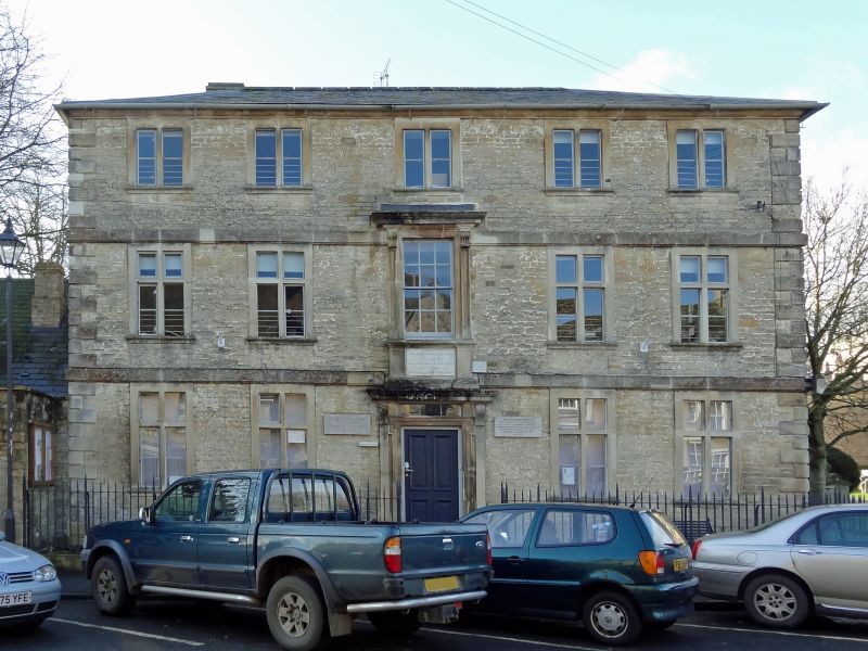
Formerly Fairford Free School, now community centre and library. Built 1738 with endowment from Farmor family, enlarged to rear in C19. Coursed and dressed stone with alternating chamfered quoins on moulded plinth, hipped slate roof with moulded stone eaves cornice, low stone stacks. Square range of 3 storeys with C19 extension to rear not of special interest. Five windows, 2-light stone mullion casements to second floor with plain beaded architraves and bull-nosed sills. First and ground floors have four 2-light stone mullion and transoms in similar surrounds. Plat bands between floors. Central window on first floor is 12-pane sash with moulded stone pilasters and cornice on consoles. Pilaster strips below bull-nosed sill with flush stone apron and inscription in capitals: "FAIRFORD FREE SCHOOL/THE GIFT OF/THE HONOURABLE MRS ELIZ FARMOR/AND MRS MARY BARKER/BUILT ANNO DOMINI MDCCXXXVIII". Doorcase below with pilasters and moulded cornice on consoles with shouldered surround to 4-panel door with bolection moulded panels and 6-pane fanlight, up 3 steps. Similar 3-windowed elevation to churchyard, with central inserted door on ground floor and wall tablet to former Master of School.
Listing NGR: SP1519301131
External links are from the relevant listing authority and, where applicable, Wikidata. Wikidata IDs may be related buildings as well as this specific building. If you want to add or update a link, you will need to do so by editing the Wikidata entry.


Other nearby listed buildings