Approximate Location Map
Large Map »
Latitude: 51.8778 / 51°52'40"N
Longitude: 0.5494 / 0°32'57"E
OS Eastings: 575581
OS Northings: 222987
OS Grid: TL755229
Mapcode National: GBR PHX.7Q4
Mapcode Global: VHJJJ.G2T9
Plus Code: 9F32VGHX+4Q
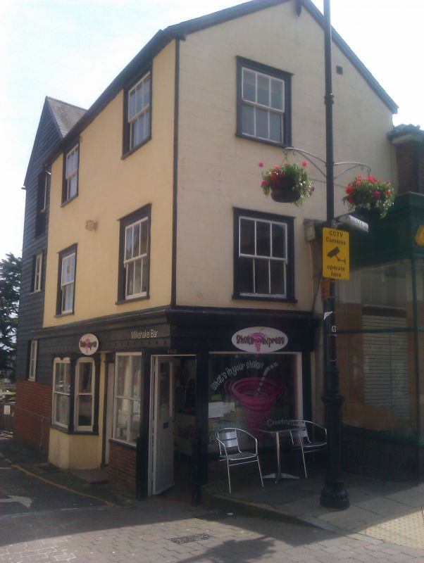
Entry Name: 112, High Street
Listing Date: 29 November 1973
Grade: II
Source: Historic England
Source ID: 1305441
English Heritage Legacy ID: 113762
ID on this website: 101305441
Location: Braintree, Essex, CM7
County: Essex
District: Braintree
Electoral Ward/Division: Braintree Central & Beckers Green
Parish: Non Civil Parish
Built-Up Area: Braintree
Traditional County: Essex
Lieutenancy Area (Ceremonial County): Essex
Church of England Parish: Braintree St Michael
Church of England Diocese: Chelmsford
Tagged with: Building
1/115 HIGH STREET
885
(South East Side)
BRAINTREE
No 112
TL 7522 1/115
II GV
2.
A C17 timber-framed and plastered house re-fronted in the late C18 or early .
C19. 3 storeys, the 2nd storey was added in the C18 or C19, The 1st storey
jettied on the front facing St Michael's Lane. 1 wLidow range on tile north-west
front and 2 window range on the north-east front, double-hung sashes with vertical
glazing bars, in flush cased frames. Roof slate, gabled at the north-west and
south-east ends. RCHM (8).
Nos 90 to 96 (even), l00, l02, l06, 112 form a group with Nos 75 to 77 (odd).
Listing NGR: TL7558122987
External links are from the relevant listing authority and, where applicable, Wikidata. Wikidata IDs may be related buildings as well as this specific building. If you want to add or update a link, you will need to do so by editing the Wikidata entry.


Other nearby listed buildings
