Approximate Location Map
Large Map »
Latitude: 52.5335 / 52°32'0"N
Longitude: -2.4185 / 2°25'6"W
OS Eastings: 371710
OS Northings: 292930
OS Grid: SO717929
Mapcode National: GBR BZ.FFBD
Mapcode Global: VH90Z.1L95
Plus Code: 9C4VGHMJ+9J
Entry Name: 19, East Castle Street
Listing Date: 9 March 1970
Grade: II
Source: Historic England
Source ID: 1307489
English Heritage Legacy ID: 254406
ID on this website: 101307489
Location: Castle Hill, Shropshire, WV16
County: Shropshire
Civil Parish: Bridgnorth
Built-Up Area: Bridgnorth
Traditional County: Shropshire
Lieutenancy Area (Ceremonial County): Shropshire
Church of England Parish: Bridgnorth
Church of England Diocese: Hereford
Tagged with: Building
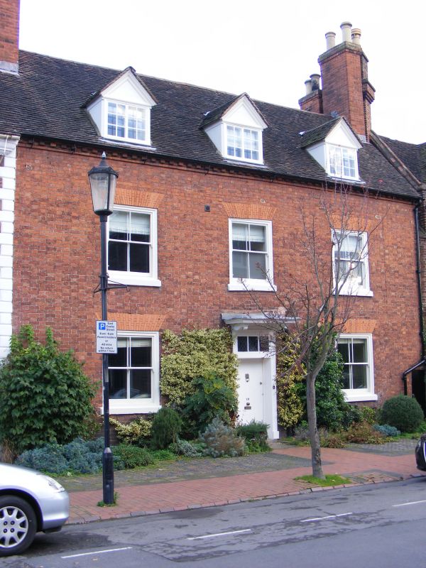
1.
1954 BRIDGNORTH
EAST CASTLE STREET
(East Side)
No 19
SO 79 SW 1/68 9.3.70.
II GV
2.
Early C19. Red brick; 2 storeys and attic; 3 sash windows with flat brick
arches; doorway in plain architrave with rectangular fanlight and moulded
wood hood on plain modillion brackets; 3 gabled dormers with moulded wood
pediments; old tiles.
Nos 18 to 33 (consec) form a group
Listing NGR: SO7171092930
External links are from the relevant listing authority and, where applicable, Wikidata. Wikidata IDs may be related buildings as well as this specific building. If you want to add or update a link, you will need to do so by editing the Wikidata entry.


Other nearby listed buildings
