Latitude: 51.0527 / 51°3'9"N
Longitude: -3.082 / 3°4'55"W
OS Eastings: 324257
OS Northings: 128703
OS Grid: ST242287
Mapcode National: GBR M2.FT68
Mapcode Global: FRA 46FB.H4B
Plus Code: 9C3R3W39+36
Entry Name: Barn Complex and Waterwheel Abutting East Side of Dutch Garden
Listing Date: 17 May 1985
Grade: II
Source: Historic England
Source ID: 1308064
English Heritage Legacy ID: 270559
ID on this website: 101308064
Location: Gotton, Somerset, TA2
County: Somerset
District: Somerset West and Taunton
Civil Parish: Cheddon Fitzpaine
Traditional County: Somerset
Lieutenancy Area (Ceremonial County): Somerset
Tagged with: Barn
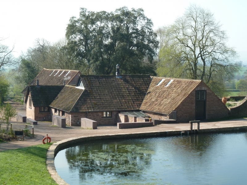
ST22NW CHEDDON FITZPAINE CP
HESTERCOMBE
5/51 Barn complex and waterwheel
abutting East side of Dutch
garden at Hestercombe
GV II
Barn complex including pumping house and waterwheel. Circa 1904-9 altered mid C20. By Edwin Lutyens for the Hon EWB
Portman. Local slate ragstone laid in courses where visible from gardens (qv) of Hestercombe House (qv), otherwise
random rubble, pantiled barn rest double Roman tiles. Plan: barn lying North-South set in to hillside at North end,
West front forming boundary of Dutch garden, waterwheel on North East front, West wing, additional buildings not of
special interest, included due to alteration. North gable end, single story plank door with divided leaded -light
above, abutting wall of Dutch garden swept up to West. South front: 2 storey, sepaental headed 4-light mullioned and
transomed leaded windows with wmoirs, wooden lintel to altered opening below, West wing altered. Overshot cast iron
waterwheel, in poor condtion at tine of survey (April 1984) in North East corner. Interior not seen. This building
probably included the machinery for feeding the water gardens from the higher pond about 10 metres to the North.
Listing NGR: ST2425728703
External links are from the relevant listing authority and, where applicable, Wikidata. Wikidata IDs may be related buildings as well as this specific building. If you want to add or update a link, you will need to do so by editing the Wikidata entry.


Other nearby listed buildings