Approximate Location Map
Large Map »
Latitude: 51.8135 / 51°48'48"N
Longitude: -0.2934 / 0°17'36"W
OS Eastings: 517740
OS Northings: 214138
OS Grid: TL177141
Mapcode National: GBR H7L.BM0
Mapcode Global: VHGPB.VPR4
Plus Code: 9C3XRP74+9J
Entry Name: 2, High Street
Listing Date: 27 September 1984
Grade: II
Source: Historic England
Source ID: 1308166
English Heritage Legacy ID: 163963
ID on this website: 101308166
Location: Wheathampstead, St. Albans, Hertfordshire, AL4
County: Hertfordshire
District: St. Albans
Civil Parish: Wheathampstead
Built-Up Area: Wheathampstead
Traditional County: Hertfordshire
Lieutenancy Area (Ceremonial County): Hertfordshire
Church of England Parish: Wheathampstead
Church of England Diocese: St.Albans
Tagged with: Building
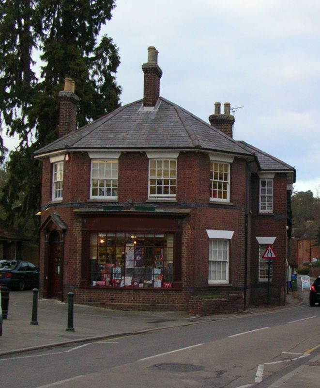
TL 1714 WHEATHAMPSTEAD HIGH STREET
(west side)
WHEATHAMPSTEAD
14/419 No 2
GV II
Shop, formerly the Corn Mill House. Late C19. Mauve brick with
blue brick banding at 1st floor sill level. Slate roof. Canted
S elevation. Shallow projection on E side. 2 storeys. 1st
floor sash windows on S and E have stucco lintels. Panelled
wooden eaves on thin carved brackets with shell motifs. C20
Georgian style shop front. 4 chimney stacks. Important closure
element at N end of High Street and group value with Corn Mill.
Listing NGR: TL1774014138
External links are from the relevant listing authority and, where applicable, Wikidata. Wikidata IDs may be related buildings as well as this specific building. If you want to add or update a link, you will need to do so by editing the Wikidata entry.


Other nearby listed buildings
