Approximate Location Map
Large Map »
Latitude: 53.5428 / 53°32'34"N
Longitude: -2.29 / 2°17'24"W
OS Eastings: 380878
OS Northings: 405165
OS Grid: SD808051
Mapcode National: GBR DWGG.0R
Mapcode Global: WH983.S6PW
Plus Code: 9C5VGPV5+4X
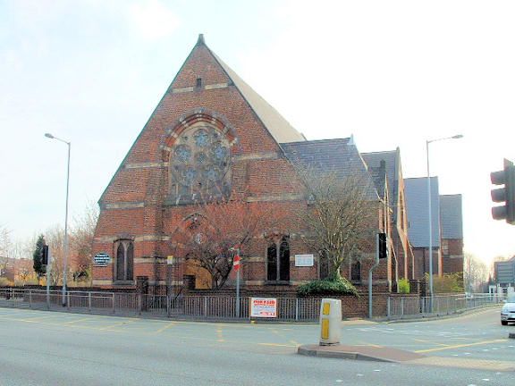
Entry Name: Besses United Reformed Church Including All Associated Buildings on Island Site
Listing Date: 29 January 1985
Grade: II
Source: Historic England
Source ID: 1309378
English Heritage Legacy ID: 210604
ID on this website: 101309378
Location: Besses o' th' Barn, Bury, Greater Manchester, M45
County: Bury
Electoral Ward/Division: Besses
Parish: Non Civil Parish
Built-Up Area: Whitefield
Traditional County: Lancashire
Lieutenancy Area (Ceremonial County): Greater Manchester
Church of England Parish: Stand All Saints
Church of England Diocese: Manchester
Tagged with: Church building Gothic Revival Building complex
SD 80 NW BURY NEW ROAD
8/175
Besses United Reformed
Church, including all
associated buildings on
- island site
- II
Gothic revival. A low, spreading complex, conspicuously sited at fork between Old
and New Bury Roads. Red brick with bands, window heads, tympana etc in other colours. Steep slate roofs. Dated 1865 in head of gable front, which has stone plate-tracery rose window under 2 centred arch. Short transepts have similar gables. Beyond east end the associated buildings present steep gables, one to north, two to south.
Listing NGR: SD8087805165
External links are from the relevant listing authority and, where applicable, Wikidata. Wikidata IDs may be related buildings as well as this specific building. If you want to add or update a link, you will need to do so by editing the Wikidata entry.


Other nearby listed buildings
