Approximate Location Map
Large Map »
Latitude: 52.5716 / 52°34'17"N
Longitude: -0.244 / 0°14'38"W
OS Eastings: 519101
OS Northings: 298532
OS Grid: TL191985
Mapcode National: GBR HZP.R49
Mapcode Global: WHHNK.7M1F
Plus Code: 9C4XHQC4+J9
Entry Name: 16, Priestgate
Listing Date: 7 February 1952
Grade: II
Source: Historic England
Source ID: 1309953
English Heritage Legacy ID: 49678
ID on this website: 101309953
Location: Peterborough, Cambridgeshire, PE1
County: City of Peterborough
Electoral Ward/Division: Central
Parish: Non Civil Parish
Built-Up Area: Peterborough
Traditional County: Northamptonshire
Lieutenancy Area (Ceremonial County): Cambridgeshire
Church of England Parish: Peterborough St John the Baptist
Church of England Diocese: Peterborough
Tagged with: Building
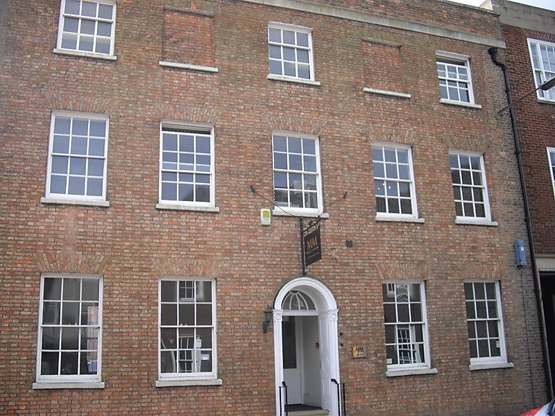
PETERBOROUGH
1.
1500
PRIESTGATE
(South Side)
No 16
TL 1998 NW 1/32 7.2.52.
II
2.
Early C19. L-shaped building in brick with slate roof. 5 storeys. Plain
parapet. 5 windows, flat arches, double hung sashes with glazing bars,
2 blocked. Panelled doorway with round arched ornamental fanlight.
Listing NGR: TL1910198532
External links are from the relevant listing authority and, where applicable, Wikidata. Wikidata IDs may be related buildings as well as this specific building. If you want to add or update a link, you will need to do so by editing the Wikidata entry.


Other nearby listed buildings
