Approximate Location Map
Large Map »
Latitude: 52.3369 / 52°20'12"N
Longitude: 0.3307 / 0°19'50"E
OS Eastings: 558887
OS Northings: 273532
OS Grid: TL588735
Mapcode National: GBR N8P.DFM
Mapcode Global: VHHJM.PJ5F
Plus Code: 9F4288PJ+P7
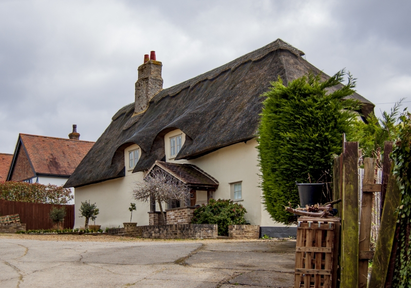
Entry Name: Mereside Cottage
Listing Date: 17 November 1983
Grade: II
Source: Historic England
Source ID: 1310347
English Heritage Legacy ID: 48870
ID on this website: 101310347
Location: Soham, East Cambridgeshire, CB7
County: Cambridgeshire
District: East Cambridgeshire
Civil Parish: Soham
Built-Up Area: Soham
Traditional County: Cambridgeshire
Lieutenancy Area (Ceremonial County): Cambridgeshire
Church of England Parish: Soham St Andrew
Church of England Diocese: Ely
Tagged with: Cottage Thatched cottage
TL 57 SE SOHAM MERESIDE
(East Side)
8/64 Mereside Cottage
II
Cottage, late C17, with gable end to road. Timber framed,
plaster rendered with half-hipped thatched roof and original
ridge stack, part rebuilt and rendered, and later side stack.
Of three bay plan with entry in south side. Three later
casements to gable end.
Listing NGR: TL5888773532
External links are from the relevant listing authority and, where applicable, Wikidata. Wikidata IDs may be related buildings as well as this specific building. If you want to add or update a link, you will need to do so by editing the Wikidata entry.


Other nearby listed buildings
