Latitude: 54.5812 / 54°34'52"N
Longitude: -1.7918 / 1°47'30"W
OS Eastings: 413554
OS Northings: 520690
OS Grid: NZ135206
Mapcode National: GBR HHXG.WJ
Mapcode Global: WHC5L.F3ZS
Plus Code: 9C6WH6J5+F7
Entry Name: Field Byre C.50 Metres East of Staindrop Cemetery
Listing Date: 30 September 1987
Grade: II
Source: Historic England
Source ID: 1310722
English Heritage Legacy ID: 111472
ID on this website: 101310722
Location: Staindrop, County Durham, DL2
County: County Durham
Civil Parish: Staindrop
Built-Up Area: Staindrop
Traditional County: Durham
Lieutenancy Area (Ceremonial County): County Durham
Church of England Parish: Staindrop
Church of England Diocese: Durham
Tagged with: Architectural structure
STAINDROP B 6279 NZ 1320 (South side, off) 18/107 Field byre c.50 metres east of Staindrop cemetery
II
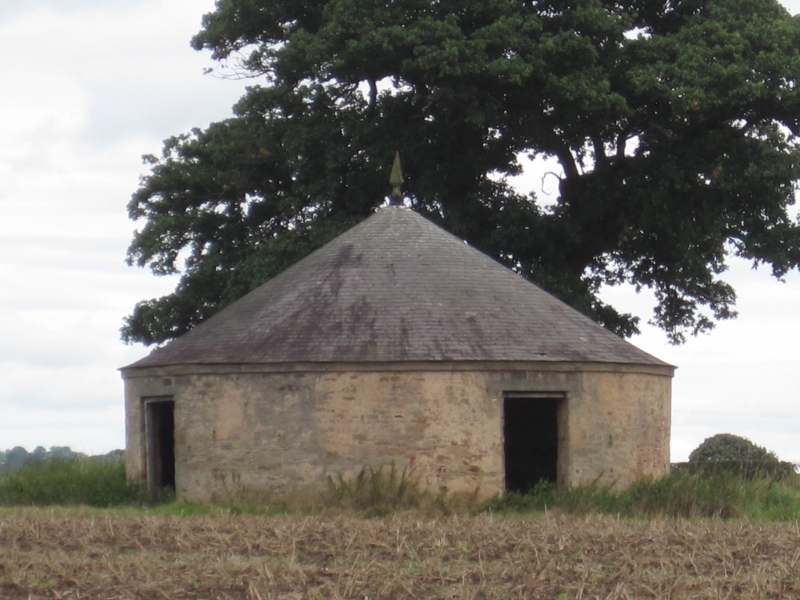
Field byre. Probably early-C19. Pinkish, thinly rendered coursed squared sandstone with plinth and ashlar dressings; roof of small thick dark grey slates with lead finial. Circular plan. One storey. 4 equally-spaced Dutch doors under flat stone lintels; lintel renewed in concrete. Plain plinth and similar eaves band. Steeply-pitched conical roof with spear finial.
Interior: rendered walls to eaves height divide space into 4; braced roof trusses from central post have 2 levels of curved purlins.
Listing NGR: NZ1355420690
External links are from the relevant listing authority and, where applicable, Wikidata. Wikidata IDs may be related buildings as well as this specific building. If you want to add or update a link, you will need to do so by editing the Wikidata entry.


Other nearby listed buildings