Approximate Location Map
Large Map »
Latitude: 50.2862 / 50°17'10"N
Longitude: -5.2419 / 5°14'30"W
OS Eastings: 169155
OS Northings: 47942
OS Grid: SW691479
Mapcode National: GBR Z3.903R
Mapcode Global: VH12C.325F
Plus Code: 9C2P7QP5+F6
Entry Name: Engine House at SW691479 (Wheal Lushington)
Listing Date: 31 October 1988
Grade: II
Source: Historic England
Source ID: 1312176
English Heritage Legacy ID: 63819
ID on this website: 101312176
Location: Porthtowan, Cornwall, TR4
County: Cornwall
Civil Parish: St. Agnes
Traditional County: Cornwall
Lieutenancy Area (Ceremonial County): Cornwall
Church of England Parish: Mount Hawke with Mithian
Church of England Diocese: Truro
Tagged with: Chimney
ST AGNES PORTHTOWAN
SW 74 NW
7/191 Engine house at SW691479 (Wheal
- Lushington)
GV II
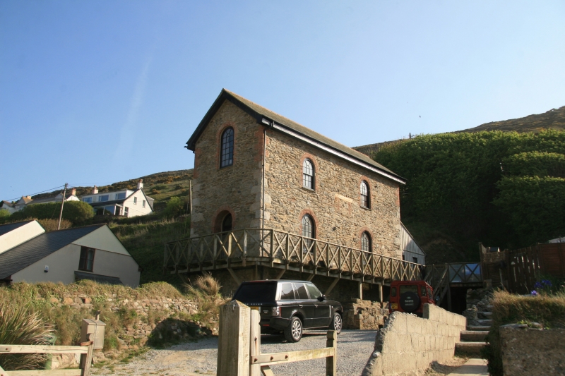
Pumping beam engine house, now used as a cafe with living accommodation above. Circa
early 1870s. Painted rubble walls. Brick arches over most of the openings. Round
rubble stack (truncated) clasping rear left-hand corner. Corrugated asbestos roof
with gable ends.
Plan: Rectangular plan engine house with round external chimney clasping rear left-
hand corner. Machinery intended for pumping (via adit in side of hill) never
installed.
Exterior: 2 storeys over cataract-pit basement. Original openings to all elevations.
Front (bob) wall has central round-headed doorway and round-headed window rising into
gable above. Right-hand (nearside) wall has 2 round-headed windows to each floor.
Left-hand (off-side) wall has window opening spanned by timber lintel ground floor
right. Rear wall has round-headed doorway (with a later extension) and round-headed
window above. C20 doors and windows.
Part of Wheal Towan Mine.
Interior not inspected.
Source: Sharpe, Adam and Smith, John. Engine Houses in St Agnes Parish. (Cornwall
Archaeological Unit survey for Carrick District Council.
Listing NGR: SW6910047900
External links are from the relevant listing authority and, where applicable, Wikidata. Wikidata IDs may be related buildings as well as this specific building. If you want to add or update a link, you will need to do so by editing the Wikidata entry.


Other nearby listed buildings
