Approximate Location Map
Large Map »
Latitude: 52.2807 / 52°16'50"N
Longitude: -0.4516 / 0°27'5"W
OS Eastings: 505730
OS Northings: 265854
OS Grid: TL057658
Mapcode National: GBR G08.SSF
Mapcode Global: VHFPH.4Y40
Plus Code: 9C4X7GJX+79
Entry Name: Barn South East of Moat Farmhouse
Listing Date: 12 August 1983
Grade: II
Source: Historic England
Source ID: 1312290
English Heritage Legacy ID: 36337
ID on this website: 101312290
Location: Swineshead, Bedford, Bedfordshire, MK44
County: Bedford
Civil Parish: Swineshead
Traditional County: Bedfordshire
Lieutenancy Area (Ceremonial County): Bedfordshire
Church of England Parish: Swineshead
Church of England Diocese: St.Albans
Tagged with: Barn
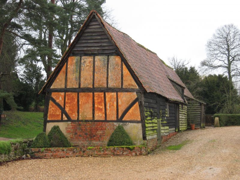
TL 0565 SWINESHEAD SANDYE LANE (West Side)
9/204 Barn South-East of Moat
Farmhouse
G V II
Barn. C18 and C19. Timber frame on red brick plinth. Weatherboarded. East gable
end has timber frame exposed with brick and colour washed plaster infill. Pantiled
roof.
Listing NGR: TL0573065854
External links are from the relevant listing authority and, where applicable, Wikidata. Wikidata IDs may be related buildings as well as this specific building. If you want to add or update a link, you will need to do so by editing the Wikidata entry.


Other nearby listed buildings
