Approximate Location Map
Large Map »
Latitude: 53.6501 / 53°39'0"N
Longitude: -1.7882 / 1°47'17"W
OS Eastings: 414095
OS Northings: 417092
OS Grid: SE140170
Mapcode National: GBR HVY7.N8
Mapcode Global: WHCB1.HJP2
Plus Code: 9C5WM626+3P
Entry Name: 18, Elmwood Avenue
Listing Date: 29 September 1978
Grade: II
Source: Historic England
Source ID: 1313838
English Heritage Legacy ID: 339828
ID on this website: 101313838
Location: Newtown, Kirklees, West Yorkshire, HD1
County: Kirklees
Electoral Ward/Division: Newsome
Parish: Non Civil Parish
Built-Up Area: Huddersfield
Traditional County: Yorkshire
Lieutenancy Area (Ceremonial County): West Yorkshire
Church of England Parish: Huddersfield Holy Trinity
Church of England Diocese: Leeds
Tagged with: Building
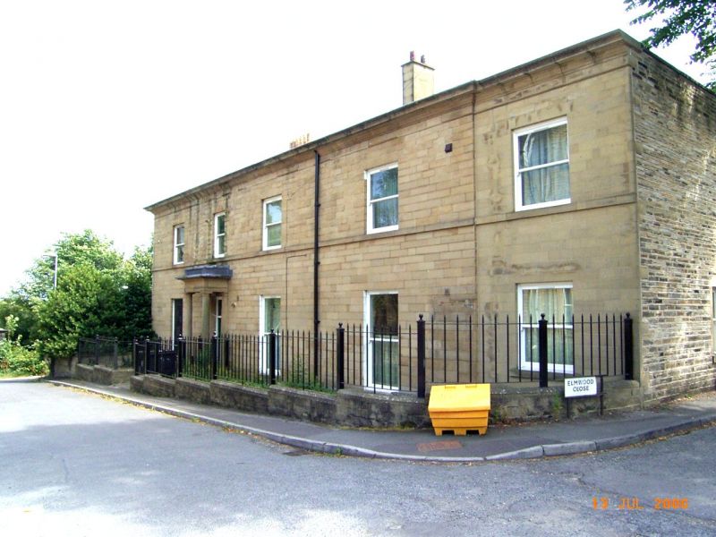
ELMWOOD AVENUE
1.
5113
(South Side)
Highfield
No 18
SE 1417 28/501
II GV
2.
Mid C19. Ashlar. Hipped stone slate roof. 2 storeys. Moulded eaves cornice.
Band. 3 ranges of sashes, and one blocked range. Door with fanlight in porch
with Tuscan columns, full entablature, and blocking course.
Listing NGR: SE1409517092
External links are from the relevant listing authority and, where applicable, Wikidata. Wikidata IDs may be related buildings as well as this specific building. If you want to add or update a link, you will need to do so by editing the Wikidata entry.


Other nearby listed buildings
