Approximate Location Map
Large Map »
Latitude: 54.4841 / 54°29'2"N
Longitude: -0.6096 / 0°36'34"W
OS Eastings: 490176
OS Northings: 510746
OS Grid: NZ901107
Mapcode National: GBR SJ5L.TC
Mapcode Global: WHG9Y.LKX9
Plus Code: 9C6XF9MR+J5
Entry Name: 30 Church Street
Listing Date: 4 December 1972
Grade: II
Source: Historic England
Source ID: 1316368
English Heritage Legacy ID: 326612
ID on this website: 101316368
Location: Whitby, North Yorkshire, YO22
County: North Yorkshire
District: Scarborough
Civil Parish: Whitby
Built-Up Area: Whitby
Traditional County: Yorkshire
Lieutenancy Area (Ceremonial County): North Yorkshire
Church of England Parish: Whitby St Mary
Church of England Diocese: York
Tagged with: Building
This list entry was subject to a Minor Amendment on 14 October 2021 to remove superfluous amendment details and to reformat the text to current standards
NZ 9010
9/289
CHURCH STREET (East Side)
No 30
GV
II
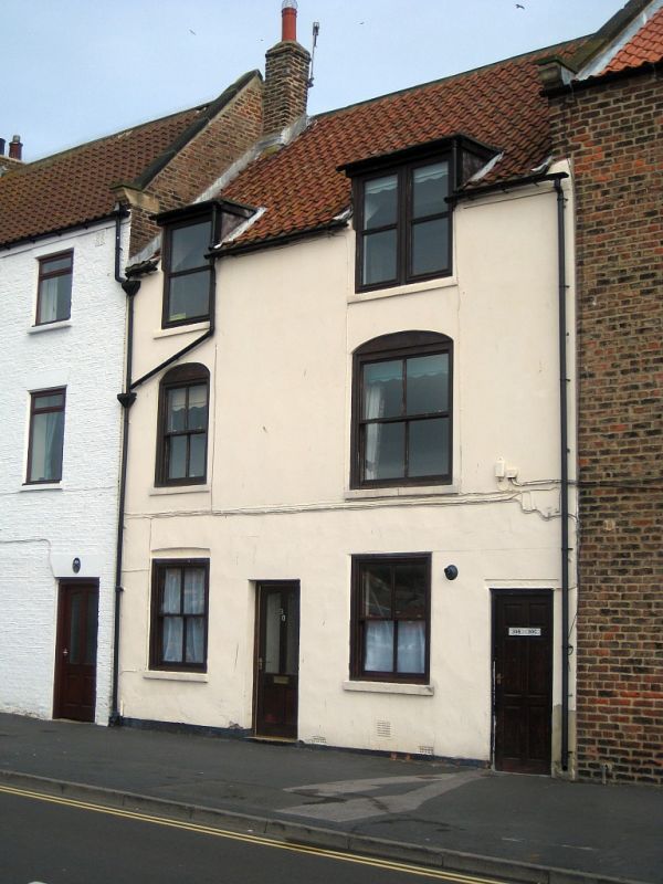
C18. Three storeys in brick. Pantile roof. Two windows, sliding sashes of two and three lights. First floor windows have elliptical relieving arches, no glazing bars, Rendered ground floor. Two windows on ground floor, modern glazing to right but retaining old frame to left. Modern door. Flat passage arch to right.
Nos 29, 30, The Ship Inn Flats and Nos 34 and 35 form a group.
Listing NGR: NZ9017610746
External links are from the relevant listing authority and, where applicable, Wikidata. Wikidata IDs may be related buildings as well as this specific building. If you want to add or update a link, you will need to do so by editing the Wikidata entry.


Other nearby listed buildings
