Latitude: 53.7844 / 53°47'3"N
Longitude: -1.069 / 1°4'8"W
OS Eastings: 461442
OS Northings: 432407
OS Grid: SE614324
Mapcode National: GBR NSZP.C4
Mapcode Global: WHFD2.K45N
Plus Code: 9C5WQWMJ+PC
Entry Name: 8, 10, and 12 Finkle Street
Listing Date: 14 November 1980
Last Amended: 29 November 2024
Grade: II
Source: Historic England
Source ID: 1316638
English Heritage Legacy ID: 325736
ID on this website: 101316638
Location: Selby, North Yorkshire, YO8
County: North Yorkshire
District: Selby
Civil Parish: Selby
Built-Up Area: Selby
Traditional County: Yorkshire
Lieutenancy Area (Ceremonial County): North Yorkshire
Church of England Parish: Selby St Mary and St Germain
Church of England Diocese: York
Tagged with: Pub
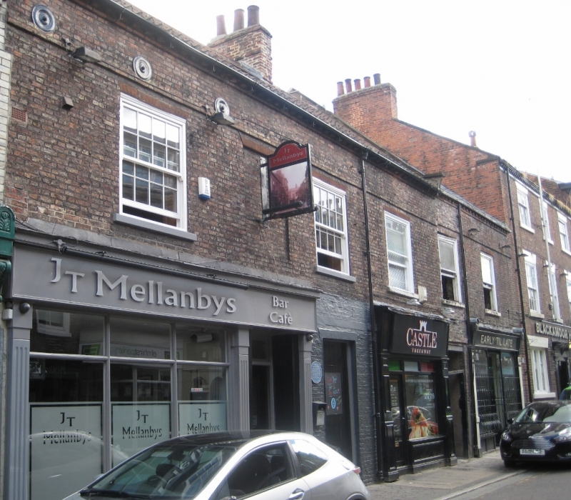
A terrace of three houses of the early to mid-C18, altered as commercial properties in the C19.
A terrace of three houses of the early to mid-C18, altered as commercial properties in the C19.
MATERIALS: fair-faced brown brick, pantile roof.
PLAN: two-storey terrace aligned south-west to north-east, with two-storey rear ranges accessed by passages between each house.
EXTERIOR: facing north-west onto Finkle Street, with a biletted eaves band and proud band above the first-floor windows. Numbers 12 and 10 (at the left) are bracketed by coped gables with shaped kneelers and have a straight vertical joint with number 8, which simply abuts the adjacent building; number 8’s bands are one brick higher than those of 12 and 10, and its ridge is also higher. Passages to the rear at the left of number 8 (with replacement three-pane fanlight over), and the right of number 12. Painted stone sills, and rubbed-brick wedge lintels.
Number 8 is of two bays, with a late-C19 shopfront to the right of the passage. The shopfront has a central recessed and splayed entrance with decorative tiled floor, and a half-glazed panelled door with overlight. Panelled stallrisers, slender baluster corner glazing bars. Framed by simple pilasters with inclined fluted consoles, pyramidal stop projections and semi-circular caps. Replacement sash windows above, with horns and no glazing bars.
Number 10 has a single replacement sash matching number 8, above an altered C20 shopfront.
Number 12 is of three bays, oversailing the former passage to the rear of number 10, and with a blind window in the centre (retaining a projecting pub sign). Its shopfront is also C20 and altered. There are tie-rod pattress plates below the eaves.
A banded brick ridge stack with three terracotta pots rises above the party wall between numbers 10 and 12, and a capped and truncated chimneystack rises over the north-east wall of number 12.
The rear of number 8 has two depressed brick relieving arches over casement windows.
Selby as a settlement dates to the Anglo-Saxon period, when it was known as Seletun (old Scandinavian for ‘sallow tree settlement’) and was referred to by the Anglo-Saxon Chronicle of AD 779. A charter of about 1030 called it Seleby and about 1050 it was Selbi. King Henry I was born in Selby in 1068 and, a year later, Benedict, a French monk from Auxerre, obtained permission from King William to establish an abbey. The Market Place has existed since the early C14. By the C15 Selby had developed thriving trade links along the East Coast and with the Low Countries. Selby Abbey succumbed to dissolution in 1539, and the core of the building became the parish church in 1618.
Selby’s commercial importance grew dramatically following the opening of the Selby Canal in 1778, becoming a notable inland port, however, after the building of Goole Docks in 1826 it suffered a very rapid decline. The town’s fortunes recovered in 1834 with the opening of the Leeds and Selby Railway, and by the early C20 it witnessed a growth in several industries served by the railways and river traffic, including flour milling, malting, oilseed milling and cattle feed production. In 1983 coal production commenced from the Selby Coalfield. Shipbuilding ended ten years later, and coal mining ceased in 2004. Since then there has been a gradual reduction in the traditional industries, although some remain.
Finkle Street is an ancient street connecting the Market Place and Micklegate, aligned roughly south-west to north-east. Finkle is both a Danish word meaning angle or corner, and an Old Norse word for elbow, or bend. In the mid-C19, the northern half of the street was known as King Street, and the property numbers were different, being changed sometime between 1912 and 1917. The properties on the western side of the street had long former medieval burgage plots to their rears. However, those on the eastern side, like numbers 8-12, had narrow and confined rear yards, filled largely with two-storey service ranges. The building was listed in 1980.
During the late C19, 8 Finkle Street was a furnishing and ironmongers shop owned by Mr Peter Watson, with a multi-paned off-set shop window. The current double-fronted shop window dates from around the turn of the C20. The shop later became Joseph Burton’s ironmongery shop, and it finally closed in the 1980s. In 1990 it was adapted to become additional lounge accommodation for the adjacent Blackamoor Head public house (National Heritage List for England entry 1132566), and has since become The Finkle Bar and Lounge.
In 1909, 10 Finkle Street was a shop called the Metropole, with the proprietor W Hoggard selling footwear produced by the Public Benefit Boot Company. In 1931, following the closure of the Public Benefit Boot Company's own shop on Ousegate, its business was transferred to 10 Finkle Street, and it continued to trade there until the 1970s. Since then, 10 Finkle Street has been a betting shop, an amusement centre, and a hot food take-away, with various alterations to its C20 shop window.
On 30 November 1761, the eminent chemist Smithson Tennant (1761 to 1815) was born at 12 Finkle Street; he first isolated the rare noble metals osmium and iridium, was awarded the Royal Society's Copley Medal, and became a Professor of Chemistry at Cambridge University. During the C19 this was a public house called Mellanby's, with several members of the Mellanby family acting as licensees. It was renamed The Elizabethan in 1953, reportedly in honour of the commemoration of the coronation of Queen Elizabeth II. The current shopfront was added in 2003. In 2010 the pub was renamed JT Mellanby's, honouring the pub's earlier name. In 2011 the upper floors were converted into accommodation and other alterations were made to the interior.
The building was formerly listed under the name ‘Nos 8, 10 and the Elizabethan Public House’.
External links are from the relevant listing authority and, where applicable, Wikidata. Wikidata IDs may be related buildings as well as this specific building. If you want to add or update a link, you will need to do so by editing the Wikidata entry.


Other nearby listed buildings