Latitude: 51.137 / 51°8'13"N
Longitude: -1.9864 / 1°59'11"W
OS Eastings: 401046
OS Northings: 137530
OS Grid: SU010375
Mapcode National: GBR 2XK.NM0
Mapcode Global: VHB5F.JP66
Plus Code: 9C3W42P7+RC
Entry Name: Court Farmhouse and Gates
Listing Date: 21 May 1986
Grade: II
Source: Historic England
Source ID: 1318749
English Heritage Legacy ID: 320580
ID on this website: 101318749
Location: Wylye, Wiltshire, BA12
County: Wiltshire
Civil Parish: Wylye
Built-Up Area: Wylye
Traditional County: Wiltshire
Lieutenancy Area (Ceremonial County): Wiltshire
Church of England Parish: Middle Wylye Valley
Church of England Diocese: Salisbury
Tagged with: Farmhouse
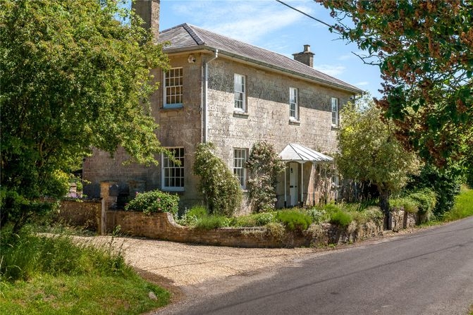
WYLYE WILTON ROAD SU 03 NW (north side) 2/146 Court Farmhouse and gates GV II Farmhouse. Early C19, additions late C19. Dressed limestone with chalk and brick to rear, Welsh slate hipped roof, ashlar stacks with moulded cappings. L-plan. Two-storey, 3-windowed front, sashes. Central door with 6 beaded panels and hipped lead porch on cast-iron posts, either side is 16-pane sash. First floor has three 16-pane sashes, deep eaves to roof. Left return has 16-pane sash to ground and first floor. Right return has 16-pane sash. Rear of main range has 16-pane sashes and central round-arched stair window, attached to rear left is later C19 rubble stone wing with sashes. Interior not accessible at time of survey (September 1985). Cast-iron handrail to stone steps up to front door from good double gates with spearheads and small iron finials.
Listing NGR: SU0104637530
External links are from the relevant listing authority and, where applicable, Wikidata. Wikidata IDs may be related buildings as well as this specific building. If you want to add or update a link, you will need to do so by editing the Wikidata entry.


Other nearby listed buildings