Latitude: 51.3897 / 51°23'22"N
Longitude: -0.9194 / 0°55'9"W
OS Eastings: 475284
OS Northings: 166177
OS Grid: SU752661
Mapcode National: GBR C6H.VRG
Mapcode Global: VHDX7.0BSJ
Plus Code: 9C3X93QJ+V6
Entry Name: Bartlett's Farmhouse
Listing Date: 26 January 1967
Grade: II*
Source: Historic England
Source ID: 1319119
English Heritage Legacy ID: 41430
ID on this website: 101319119
Location: Wokingham, Berkshire, RG2
County: Wokingham
Civil Parish: Arborfield and Newland
Traditional County: Berkshire
Lieutenancy Area (Ceremonial County): Berkshire
Church of England Parish: Arborfield
Church of England Diocese: Oxford
Tagged with: Farmhouse
ARBORFIELD AND NEWLAND SWALLOWFIELD ROAD SU 76 NE (south-east side)
9/27 Bartlett's Farmhouse 26.1.67 G.V. II*
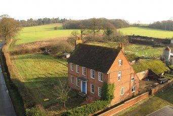
Farmhouse. Late C16 extended on front in C18. Brick with plinth and first floor string; old tile gabled roof, with chimney on left. 2 storeys and attics. Rectangular plan with catslide roof at rear and some timber frame exposed. Entrance front:- 5 bays of which the 3 left hand bays project slightly, the 2 bays on right are in C16 brick. Sash windows with glazing bars in architrave frames, a 6 panelled entrance door in centre with 3-pane rectangular fanlight in doorcase of fluted Doric pilasters supporting entablature with dentil bed mould to cornice hood; approached by 2 stone steps. Interior:- C18, panelling to staircase hall and room to left and in principal bedrooms; stairs with carved balusters and moulded handrail. B.O.E. (Berks) p.66.
Listing NGR: SU7526366156
External links are from the relevant listing authority and, where applicable, Wikidata. Wikidata IDs may be related buildings as well as this specific building. If you want to add or update a link, you will need to do so by editing the Wikidata entry.


Other nearby listed buildings