Latitude: 51.8169 / 51°49'0"N
Longitude: -0.815 / 0°48'53"W
OS Eastings: 481781
OS Northings: 213809
OS Grid: SP817138
Mapcode National: GBR D2X.4R8
Mapcode Global: VHDV4.TLJH
Plus Code: 9C3XR58P+Q2
Entry Name: 4, Church Street
Listing Date: 5 February 1973
Grade: II
Source: Historic England
Source ID: 1319198
English Heritage Legacy ID: 41859
ID on this website: 101319198
Location: Aylesbury, Buckinghamshire, HP20
County: Buckinghamshire
Civil Parish: Aylesbury
Built-Up Area: Aylesbury
Traditional County: Buckinghamshire
Lieutenancy Area (Ceremonial County): Buckinghamshire
Church of England Parish: Aylesbury
Church of England Diocese: Oxford
Tagged with: Building
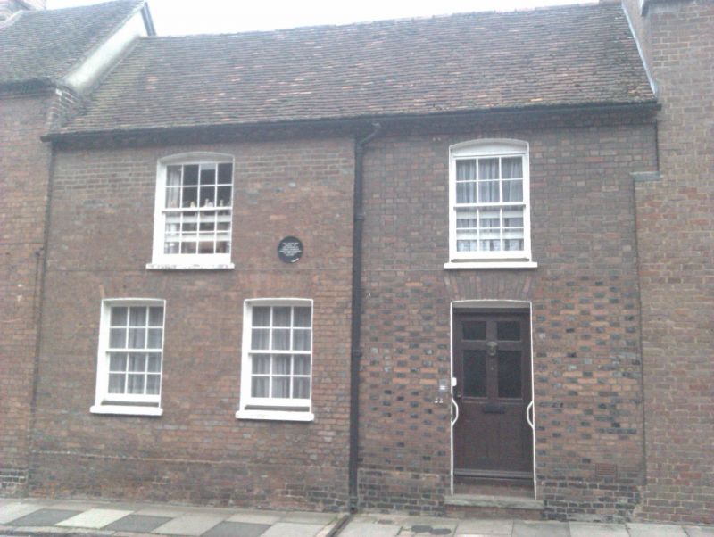
1. 799 CHURCH STREET (South-West Side) No 4 SP 8113 NE 1/239
II
2. C18 or early C19. Red and vitreous brick, old tiled roof. 2 storeys, corbelled brick cornice. 2 sashes in reveals under slightly cambered arches. 1 storey wing on right, '
Listing NGR: SP8178113808
External links are from the relevant listing authority and, where applicable, Wikidata. Wikidata IDs may be related buildings as well as this specific building. If you want to add or update a link, you will need to do so by editing the Wikidata entry.


Other nearby listed buildings