Approximate Location Map
Large Map »
Latitude: 51.1447 / 51°8'40"N
Longitude: 0.8333 / 0°49'59"E
OS Eastings: 598279
OS Northings: 142196
OS Grid: TQ982421
Mapcode National: GBR RWV.1J9
Mapcode Global: VHKKM.DHDB
Plus Code: 9F324RVM+V8
Entry Name: 18, the Street
Listing Date: 10 October 1980
Grade: II
Source: Historic England
Source ID: 1320113
English Heritage Legacy ID: 180955
ID on this website: 101320113
Location: Great Chart, Ashford, Kent, TN23
County: Kent
District: Ashford
Civil Parish: Great Chart with Singleton
Built-Up Area: Ashford (Ashford)
Traditional County: Kent
Lieutenancy Area (Ceremonial County): Kent
Tagged with: Building
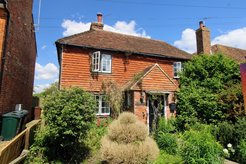
1.
5272 GREAT CHART THE STREET
(north-west side)
No 18
TQ 9842 26/61
II GV
2.
Early C19. Two storeys. Ground floor red brick with grey headers. First
floor tile-hung. Hipped tiled roof. Two casements and canopied bays to ground
floor. Simple doorcase with flat weatherhood.
Listing NGR: TQ9827842197
External links are from the relevant listing authority and, where applicable, Wikidata. Wikidata IDs may be related buildings as well as this specific building. If you want to add or update a link, you will need to do so by editing the Wikidata entry.


Other nearby listed buildings
