Latitude: 50.5893 / 50°35'21"N
Longitude: -4.8677 / 4°52'3"W
OS Eastings: 197111
OS Northings: 80541
OS Grid: SW971805
Mapcode National: GBR ZR.TW4W
Mapcode Global: FRA 07PH.X0W
Plus Code: 9C2QH4QJ+PW
Entry Name: Wall to Beach on North East Side of Portquin
Listing Date: 26 June 1987
Grade: II
Source: Historic England
Source ID: 1320628
English Heritage Legacy ID: 351442
ID on this website: 101320628
Location: Port Quin, Cornwall, PL29
County: Cornwall
Civil Parish: St. Endellion
Traditional County: Cornwall
Lieutenancy Area (Ceremonial County): Cornwall
Church of England Parish: St Endellion
Church of England Diocese: Truro
Tagged with: Wall
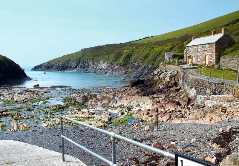
SW 98 SE ST ENDELLION PORTQUIN
1/110 Wall to beach on north east side of
Portquin
-
GV II
Wall to beach. Possibly C18. Vertically laid slate stones on bed rock forming north
wall to beach. Wall continues to right (east) with ashlar and stone rubble wall and
to left (west) with stone rubble wall below Quay Cottage (qv).
Listing NGR: SW9711180541
External links are from the relevant listing authority and, where applicable, Wikidata. Wikidata IDs may be related buildings as well as this specific building. If you want to add or update a link, you will need to do so by editing the Wikidata entry.


Other nearby listed buildings