Approximate Location Map
Large Map »
Latitude: 51.5815 / 51°34'53"N
Longitude: -2.5805 / 2°34'49"W
OS Eastings: 359871
OS Northings: 187121
OS Grid: ST598871
Mapcode National: GBR JR.CMLN
Mapcode Global: VH882.7H4Z
Plus Code: 9C3VHCJ9+JQ
Entry Name: The Bee Garden
Listing Date: 21 October 1952
Last Amended: 5 December 1984
Grade: II
Source: Historic England
Source ID: 1321054
English Heritage Legacy ID: 35316
ID on this website: 101321054
Location: Olveston, South Gloucestershire, BS35
County: South Gloucestershire
Civil Parish: Olveston
Built-Up Area: Olveston
Traditional County: Gloucestershire
Lieutenancy Area (Ceremonial County): Gloucestershire
Church of England Parish: Olveston
Church of England Diocese: Bristol
Tagged with: Architectural structure
ST 58 NE
7/207
21.10.52
OLVESTON
OLVESTON
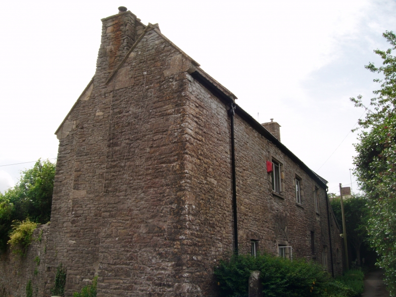
The Bee Garden (formerly listed as barn 30 yards north of Olveston Court Farmhouse)
G.V.
II
House, probably former barn. C15/C16 with later alterations. Rubble, stone
dressings, partly rendered, pantiled roof with raised coped verges and kneelers,
external gable stacks. East elevation of 2 storeys and 2 windows, 1st floor
has window with depressed 4-centred arch, chamfered surround and iron lattice,
ground floor has 4 C20 windows, gabled porch, 1½ storey lean-to to south with
C20 door and windows. North elevation has gabled tower (probably former stair)
with slits in chamfered stone surrounds, blocked 4-centred arched door in
chamfered surround in external stack; west elevation has 3 windows, all C20,
ground left and right have relieving arch, ground and lst floor right have
stopped hood mould, former door to right has depressed 4-centred arch with
hollow chamfer, now blocked and with C20 window. Interior: 1st floor has
fireplace with depressed 4-centred arched head and chamfered surround, 3 bays to
north visible of roof, 2 rows of purlins and 2 tiers of windbraces, collars and
winding wheel.
Listing NGR: ST5987187121
External links are from the relevant listing authority and, where applicable, Wikidata. Wikidata IDs may be related buildings as well as this specific building. If you want to add or update a link, you will need to do so by editing the Wikidata entry.


Other nearby listed buildings
