Approximate Location Map
Large Map »
Latitude: 51.9842 / 51°59'3"N
Longitude: -0.5031 / 0°30'11"W
OS Eastings: 502896
OS Northings: 232808
OS Grid: TL028328
Mapcode National: GBR G3V.KMM
Mapcode Global: VHFR0.7DD7
Plus Code: 9C3XXFMW+MQ
Entry Name: The Grange
Listing Date: 3 May 1985
Grade: II
Source: Historic England
Source ID: 1321712
English Heritage Legacy ID: 38103
ID on this website: 101321712
Location: Westoning, Central Bedfordshire, MK45
County: Central Bedfordshire
Civil Parish: Westoning
Built-Up Area: Westoning
Traditional County: Bedfordshire
Lieutenancy Area (Ceremonial County): Bedfordshire
Church of England Parish: Westoning
Church of England Diocese: St.Albans
Tagged with: Building
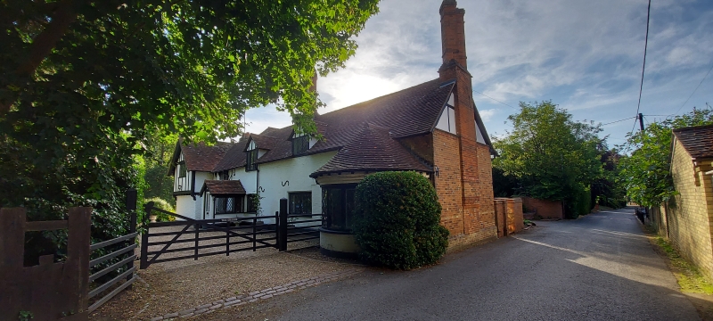
WESTONING
TL 0232 CHURCH ROAD
21/121 The Grange
GV II
House. Late C16 or early C17, considerably reworked late C19. Substantial
timber framed structure with red brick infilling, many bricks vitrified.
Later additions in red and yellow brick, parts colourwashed. Clay tile roofs.
L-plan, NE block 2-storeyed, SW block one storey and attics. NE wing:
central projecting gable, probably originally jettied but now built-out with
exposed corbels. Gable has 7-light ground floor window and 5-light first
floor window. These are flanked by single lights to ground floor and 2-light
windows to first floor. All apparently C20 casements with diamond leading.
Door to LH. External brick stack to RH gable with paired diagonal shafts. SW
block, E elevation: RH part timber framed, LH part C19 brick extension.
Similar fenestration to NE wing. Brick part has jettied gable to LH. Jetty
has colourwashed render with applied timber framing, mullion and transom
window with honeycomb leading, and initials "I.W.C.C."
Listing NGR: TL0289632808
External links are from the relevant listing authority and, where applicable, Wikidata. Wikidata IDs may be related buildings as well as this specific building. If you want to add or update a link, you will need to do so by editing the Wikidata entry.


Other nearby listed buildings
