Latitude: 52.0062 / 52°0'22"N
Longitude: -0.4095 / 0°24'34"W
OS Eastings: 509267
OS Northings: 235393
OS Grid: TL092353
Mapcode National: GBR G3S.58Q
Mapcode Global: VHFQV.VTCW
Plus Code: 9C4X2H4R+F5
Entry Name: Statue of Atlas approximately 250m south-east of Wrest Park House
Listing Date: 10 January 1985
Last Amended: 18 May 2012
Grade: II
Source: Historic England
Source ID: 1321795
English Heritage Legacy ID: 37732
ID on this website: 101321795
Location: Central Bedfordshire, MK45
County: Central Bedfordshire
Civil Parish: Silsoe
Traditional County: Bedfordshire
Lieutenancy Area (Ceremonial County): Bedfordshire
Church of England Parish: Silsoe
Church of England Diocese: St.Albans
Tagged with: Statue
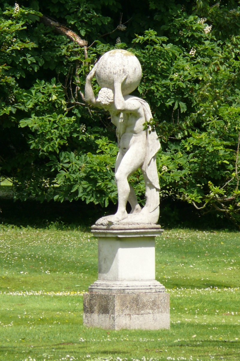
Statue of Atlas, early C18 with C19 pedestal.
MATERIALS: Portland Stone with stone base and plinth.
DESCRIPTION: this statue is understood to represent the Greek god Atlas, who is portrayed as a stooping figure with the globe bearing down on his shoulders and held in place by his hands. A long garland of drapery hangs over his left shoulder which falls to a tree stump behind his left leg; the other end passing across his chest to join to his right. Atlas is conceived as a muscular figure with a strongly formed face, large nose and thick beard and hair. The drapery emphasises his nakedness and a small hole cut into the stone just above his pubic hair is thought to be the residual hole from a C19 addition of a fig leaf. The base is naturalistic with a secondary base beneath. The latter appears to be of sandstone, roughly moulded into a Torus moulding and is almost certainly a later addition. The pedestal is thought to be C19 with curved corners on the moulded cap and base; a square die and the whole raised on a masonry plinth. The statue is weathered; the hands and feet have lost a considerable amount of detail. There are earthworks indicating that a pond previously surrounded this statue, but has since silted up.
Wrest Park belonged to the Grey family from the Middle Ages until the early C20. In 1702, Wrest became the property of Henry de Grey who, by 1710, had become the Duke of Kent. Henry was determined to improve the status of Wrest. At this time the gardens to the south were enlarged, alterations made to the water courses, and a number of garden buildings were constructed. A summer house was placed by the mill pond and a greenhouse was added to the Orange Garden. The architect Thomas Archer was responsible for many of these structures including the Pavilion (Grade I) which marked the southern limit of the garden as defined by the Old Brook. The alignment of the Old Brook is still maintained as the boundary between the parishes of Silsoe and Gravenhurst. Cain Hill was incorporated into the landscape as an eye catcher, its presence emphasised by the geometric axis which, eventually, led east from the house and north-east from the Archer Pavilion partly in the form of avenues.
In the 1720s additional land was acquired, various alterations to the canals were carried out and several garden buildings were commissioned, from the Italian architects Filippo Juvarra and Giacomo Leoni, but also from others, predominantly Nicholas Hawksmoor, William Kent and James Gibbs. Of these the Temple of Diana (now demolished), the West Half House (Grade II) and the East Half House (Grade II) were built. The allees (avenues) and squares, either side of the Great Canal, were also created by 1726 marking the peak of the formal garden at Wrest. Two plans drawn by Rocque in 1735 and 1737 illustrate some of these changes. In 1729 work resumed with additions including an amphitheatre to the north of the bowling green and the creation of the serpentine canal. A greenhouse (on the site of the current Orangery) and the addition to, and enlargement of Bowling Green House (Grade II*) were also completed, both by Batty Langley.
The statue of Atlas is understood to date to the early C18 when the Duke of Kent resided at Wrest, probably one of the many additions the Duke made to the gardens at that time. The original location of the statue in the gardens is unknown and the earliest recorded date of it in its current location, to the east of the site of the old house, is only 1900.
The statue of Atlas, approximately 250m south-east of Wrest Park House is designated at Grade II for the following principal reasons:
* Architectural Interest: as a finely executed piece of sculpture;
* Artistic interest: in its representation of an iconic mythological figure;
* Historic interest: for its association with Wrest at a time of intense development and deliberate upgrading of the status of the house, garden and wider landscape;
* Group Value: in recognition of its contribution to the structural and aesthetic composition of a Grade I Registered Park and Garden and its physical association with many other listed buildings.
External links are from the relevant listing authority and, where applicable, Wikidata. Wikidata IDs may be related buildings as well as this specific building. If you want to add or update a link, you will need to do so by editing the Wikidata entry.


Other nearby listed buildings