Approximate Location Map
Large Map »
Latitude: 51.452 / 51°27'7"N
Longitude: -0.9682 / 0°58'5"W
OS Eastings: 471790
OS Northings: 173059
OS Grid: SU717730
Mapcode National: GBR QMG.LY
Mapcode Global: VHDWT.5RHS
Plus Code: 9C3XF22J+QP
Entry Name: 72 London Street
Listing Date: 14 December 1978
Last Amended: 8 January 2024
Grade: II
Source: Historic England
Source ID: 1321902
English Heritage Legacy ID: 39048
ID on this website: 101321902
Location: Reading, Berkshire, RG1
County: Reading
Electoral Ward/Division: Katesgrove
Parish: Non Civil Parish
Built-Up Area: Reading
Traditional County: Berkshire
Lieutenancy Area (Ceremonial County): Berkshire
Church of England Parish: Reading St Giles
Church of England Diocese: Oxford
Tagged with: Building
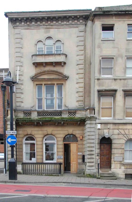
72 London Street, a former savings bank, built in 1849 to designs by John Billing.
Former savings bank, 1849, by John Billing.
MATERIALS: the street-facing, east elevation is faced in Bath Stone ashlar, and the ground floor channelled. The south elevation is exposed red brick, and the rear, west, elevation, is painted. The roof is flat.
PLAN: the building is an irregular rectangle on plan, oriented east/west, with the principal elevation facing east to London Street. This elevation is recessed from the line of the neighbouring buildings.
EXTERIOR: the building is Italianate in style. The principal frontage is arranged over three storeys, with basement. The set-back elevation is flanked by rusticated piers connecting to the neighbouring buildings (numbers 70 and 74 London Street); a parapet turns inwards to the main elevation, becoming a false balcony with stone guilloche and fretwork front. Between the supporting brackets, the frieze is engraved with the words ‘Reading Savings Bank’. The ground floor has three round-headed openings of equal size: the doorway with replacement double doors to the north, and two windows to the south, with pilastered window frames. The upper part of the frontage breaks forward slightly as a sort of frontispiece, with heavy rusticated quoins; there is a heavy modillion and panel cornice to the projecting eaves. On the first floor is a large tripartite window with a segmental pediment; the smaller second-floor window has tripartite lights with rounded arches on piers, behind a corbelled flat-bow stone balcony. Substantial original railings survive to the area. The south elevation of the building is blind, apart from a ground-floor opening to the west. The west elevation is four storeys high, with a single window at first- and second-floor level, and two windows to the third floor. The ground floor is obscured by the later single-storey annexe.
The first written record of Reading dates from the ninth century when the name seems to have referred to a tribe, called Reada’s people. It is possible that there was a river port here during the Roman occupation, and by 1086 Reading had grown into a town, recorded in the Domesday Book. The early Anglo-Saxon settlement is believed to have been located in the Castle Street and St Mary’s area, which has St Mary’s Minster at its heart.
After Reading Abbey was founded in 1121, the town grew substantially as a place of pilgrimage as well as an important ecclesiastical and trading centre, with cloth production as the principal industry. Reading’s increasing prosperity saw the establishment of the new Market Place (drawing trade away from the old marketplace at St Mary’s Butts), and of what is today known as London Street, an extension to the High Street, which facilitated trade to and from London. By 1525, Reading had become the largest town in Berkshire. Following its dissolution in 1539, Reading Abbey became a royal palace. The cloth and leather trades continued to flourish and by 1611 the town’s population had grown to over 5,000. John Speed’s map shows that by that year, both sides of London Street had been developed with continuous frontages for a considerable distance southward, beyond the modern junction with Crown Street/London Road. Several buildings which predate Speed’s map survive on London Street, some concealed behind later brick façades.
Following significant upheaval during the Civil War, the town flourished during the C18 and C19. Several developments during this period spurred further growth and prosperity, including the arrival of the Great Western Railway, improvements to the navigability of the River Kennet, and the expansion of the local brewing industry. The survival of many fine Georgian and Victorian buildings along London Street testifies to its prosperity during this period.
72 London Street was built in 1849 by the architect John Billing (1816-1863) as the Reading Savings Bank; Billing was born in Reading and practised in the area throughout his career, serving as Borough Surveyor until the mid-1850s. In 1856 he was made a Fellow of the Royal Institute of British Architects. The Reading Board of Health Map (1853) shows that at that time the building had a rear annexe and a long garden. The building’s plan appears to have remained largely unchanged until the early C21 when the rear range was rebuilt as a three-storey serviced apartment block (72a London Street) connected via a ground-floor annexe to 72 London Street. In the early C21, the building was converted from offices to a doctor’s surgery, which is its current (2023) function. Archaeological finds made to the rear of the plot – a complete medieval pot and two lines of post holes - confirm the use of the site during the medieval period.
72 London Street is listed at Grade II for the following principal reasons:
Architectural interest:
* as a building of the mid-C19 which contributes to the character of an architecturally varied historic streetscape.
Group value:
* the building is in close proximity to a large number of listed buildings and forms part of a strong historic grouping.
External links are from the relevant listing authority and, where applicable, Wikidata. Wikidata IDs may be related buildings as well as this specific building. If you want to add or update a link, you will need to do so by editing the Wikidata entry.


Other nearby listed buildings
