Approximate Location Map
Large Map »
Latitude: 51.4472 / 51°26'49"N
Longitude: -1.0007 / 1°0'2"W
OS Eastings: 469539
OS Northings: 172495
OS Grid: SU695724
Mapcode National: GBR QDJ.BN
Mapcode Global: VHDWS.LWTG
Plus Code: 9C3WCXWX+VP
Entry Name: 76, Bath Road
Listing Date: 14 December 1978
Grade: II
Source: Historic England
Source ID: 1321987
English Heritage Legacy ID: 38757
ID on this website: 101321987
Location: Southcote, Reading, Berkshire, RG30
County: Reading
Electoral Ward/Division: Southcote
Parish: Non Civil Parish
Built-Up Area: Reading
Traditional County: Berkshire
Lieutenancy Area (Ceremonial County): Berkshire
Church of England Parish: St Mark and All Saints, Reading
Church of England Diocese: Oxford
Tagged with: Building
BATH ROAD
1.
5128
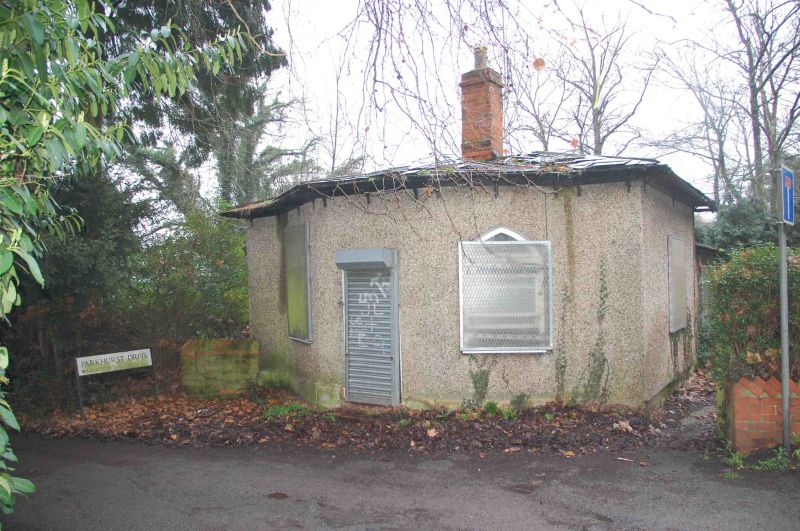
No 76
SU 67 SE 16/406
II
2.
Circa 1813-28. Probably former entrance lodge to Prospect Park. Single storey
altered with modern windows and pebbledash rendering. Slate roof. Angled
bay to west with pointed windows. Similar window to south. Trellis porch
C20. Extension to east.
Listing NGR: SU6953972495
External links are from the relevant listing authority and, where applicable, Wikidata. Wikidata IDs may be related buildings as well as this specific building. If you want to add or update a link, you will need to do so by editing the Wikidata entry.


Other nearby listed buildings
