Approximate Location Map
Large Map »
Latitude: 51.0631 / 51°3'47"N
Longitude: -1.3158 / 1°18'56"W
OS Eastings: 448042
OS Northings: 129525
OS Grid: SU480295
Mapcode National: GBR 861.B4W
Mapcode Global: FRA 8649.M7L
Plus Code: 9C3W3M7M+6M
Entry Name: Royal Oak Public House
Listing Date: 21 September 1999
Grade: II
Source: Historic England
Source ID: 1322135
English Heritage Legacy ID: 477445
Also known as: Royal Oak, Winchester
Royal Oak
ID on this website: 101322135
Location: Winchester, Hampshire, SO23
County: Hampshire
District: Winchester
Electoral Ward/Division: St Michael
Parish: Non Civil Parish
Built-Up Area: Winchester
Traditional County: Hampshire
Lieutenancy Area (Ceremonial County): Hampshire
Church of England Parish: Winchester Holy Trinity
Church of England Diocese: Winchester
Tagged with: Pub
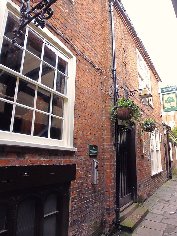
SU 4829 NW WINCHESTER
ROYAL OAK PASSAGE
869/3/10029 Royal Oak Public House
II
House, now (and since C17) a public house. Probably C15, added to and altered C16, C17, C18, C19 and C20. Timber-framed clad in red brick in Flemish or irregular Flemish bond on east elevation, painted brick and tile-hanging to west and north elevations. Plain tile roofs. Brick chimneys. Two 2-storey 3-bay parallel ranges running east-west, the southern range with partial undercroft, the northern range retaining evidence of former 2-bay open hall or solar; gabled north wing running north-south. C20 small-pane wooden casement windows or, on east elevation, sash windows with glazing bars. East elevation, of several periods, has stepped dentilled eaves, C20 entrance with Tudor-arched door and bricked-up entrance with pointed-arched chamfered surround. Interior: southern range: undercroft has walling of flint cobble and some clunch and some large-scantling joists; one exposed queen-post roof truss. The central (hall) range on 1st floor has framed wall (running north-south) with posts, mid-rail and arch brace and, at this position on ground floor, a beam with slots from former studs and deep hollow moulding to arris which is returned on adjacent beam. Roof not inspected but recorded as having one arch-braced collared truss, purlins, curved wind-braces, rafters and plastered wattle truss-infill between east bay and hall/solar. Documentary records concerning this property, or its predecessors, exist from the C14. Bob Edwards, Hampshire County Council Report. A well-documented medieval building which retains a significant amount of its medieval fabric.
Listing NGR: SU4803929520
External links are from the relevant listing authority and, where applicable, Wikidata. Wikidata IDs may be related buildings as well as this specific building. If you want to add or update a link, you will need to do so by editing the Wikidata entry.


Other nearby listed buildings
