Latitude: 54.5135 / 54°30'48"N
Longitude: -1.8127 / 1°48'45"W
OS Eastings: 412226
OS Northings: 513147
OS Grid: NZ122131
Mapcode National: GBR HJS7.CT
Mapcode Global: WHC5S.4T38
Plus Code: 9C6WG57P+9W
Entry Name: Roman Catholic Church of St Mary
Listing Date: 28 October 1987
Grade: II
Source: Historic England
Source ID: 1322759
English Heritage Legacy ID: 111774
Also known as: St Mary's Church, Wycliffe
ID on this website: 101322759
Location: St Mary's Roman Catholic Church, Hutton Magna, County Durham, DL12
County: County Durham
Civil Parish: Wycliffe with Thorpe
Traditional County: Yorkshire
Lieutenancy Area (Ceremonial County): County Durham
Church of England Parish: Wycliffe St Mary
Church of England Diocese: Leeds
Tagged with: Church building
NZ 11 SW WYCLIFFE WITH THORPE
7/183 Roman Catholic Church of St. Mary
GV II
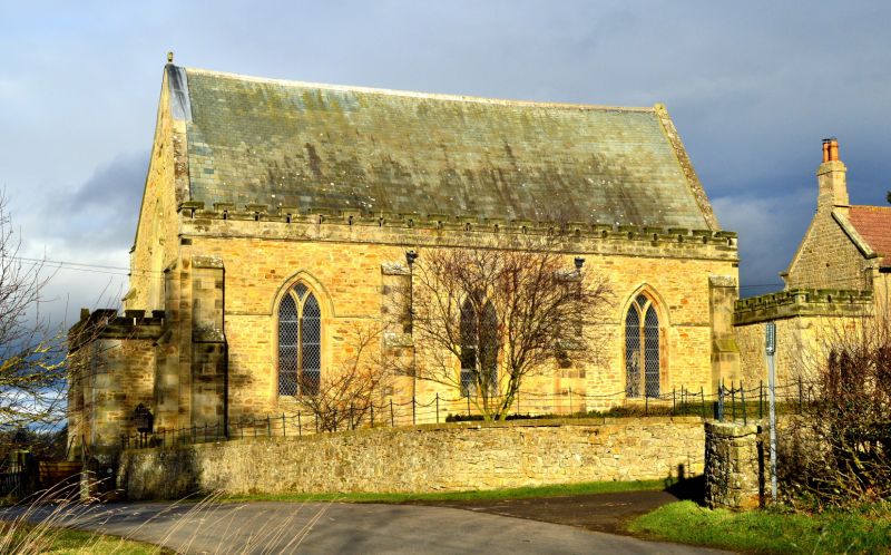
Roman Catholic Church, 1849. Rubble with tooled-and-margined stone buttresses, ashlar dressings and parapet; graduated Lakeland slate roof. Aisleless 3-bay body with west porch. C14 style. Stepped buttresses at angles and between bays; string carried up over windows as hoodmould. Flat-roofed west porch has double flight of steps, with low moulded parapet at head, to central arch of 3-bay double-chamfered arcade; side arches boarded; string below embattled parapet with pierced merlons. Above porch a 3-light window below spheric triangle window; and pointed niche in gable. West door, inside porch, has studded double doors with scrolled hinges in moulded arch with sacred monograms as hoodmould stops. Side walls shows 2-light windows with Y tracery, and similar parapet; coped end gables. East end shows blocked 5-light window and quatrefoil in gable.
Interior: Plastered. Freestone and marble altar, and panelled reredos with kneeling angels under crocketed arches. Font has octagonal bowl with raised shields, one with ihs, in fleur-de-lys borders, probably C15; later shaft and base.
Prominent hilltop position.
Listing NGR: NZ1222613147
External links are from the relevant listing authority and, where applicable, Wikidata. Wikidata IDs may be related buildings as well as this specific building. If you want to add or update a link, you will need to do so by editing the Wikidata entry.


Other nearby listed buildings