Approximate Location Map
Large Map »
Latitude: 50.732 / 50°43'55"N
Longitude: -2.7564 / 2°45'22"W
OS Eastings: 346715
OS Northings: 92754
OS Grid: SY467927
Mapcode National: GBR PP.0CKG
Mapcode Global: FRA 5734.PZH
Plus Code: 9C2VP6JV+QF
Entry Name: 27 Church Street
Listing Date: 19 September 1975
Last Amended: 10 October 2022
Grade: II
Source: Historic England
Source ID: 1324085
English Heritage Legacy ID: 104490
ID on this website: 101324085
Location: New Zealand, Dorset, DT6
County: Dorset
Civil Parish: Bridport
Built-Up Area: Bridport
Traditional County: Dorset
Lieutenancy Area (Ceremonial County): Dorset
Church of England Parish: Bridport St Mary
Church of England Diocese: Salisbury
Tagged with: Building
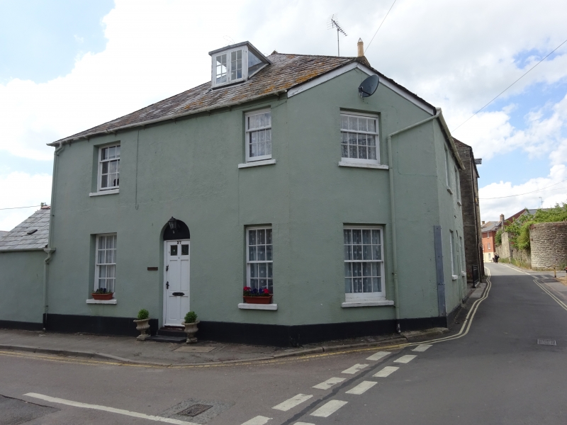
House; late C18 or early C19. It was sub-divided by 1962 and reverted to a single dwelling in 1992. Late-C20 and early-C21 alterations.
House; late C18 or early C19. It was sub-divided by 1962 and reverted to a single dwelling in 1992. Late-C20 and early-C21 alterations.
MATERIALS: it is constructed of painted and partly-rendered stone rubble under a hipped slate roof with a brick stack below the ridge. The single-storey additions to the rear are also painted and/or rendered stone rubble with slate roofs.
PLAN: the house is double-depth, and has a roughly-square plan, with two small additions to the rear.
EXTERIOR: the building has two storeys and attics. Its Church Lane elevation is symmetrical, with a central round-headed entrance containing a modern panel door with glazed upper lights and a blind fanlight, flanked by six/six timber sash windows. The two first-floor sash windows are three/six, and there is a rooflight. The sash window in the angled, single bay to the corner are of early-C21 date and match the existing windows of the Church Street elevation. The north elevation facing Folly Mill Lane is of two bays. The left-hand bay has a two-light casement on both the ground and first floors, while the other bay has a former entrance with a modern panelled door (lacking door furniture) and a blind semi-circular fanlight; a late-C20 ground-floor two-light casement with glazing bars; a similar first-floor window and a skylight. The rear elevation is largely masked by the single-storey additions which have late-C20/early-C21 windows and doors.
The later C18 and C19 was a period of prosperity for Bridport, partly due to a growth in trade with Newfoundland and a switch from manufacturing ropes to nets (Bridport Historic Towns, 2008). It was also a period when parts of the town’s historic core were rebuilt, with new houses built within existing property boundaries or by amalgamating plots. Church Street is located in an area of the town that may have medieval origins. It is shown on the Tithe Map from 1845 but no properties apart from 14 Church Street are depicted, though this may be because none of the buildings were subject to tithes rather than them not being present by this time. Historic Ordnance Survey maps from 1890 to 1929 show a single dwelling on the plot occupied by 27 Church Street, at the junction between this road and Folly Mill Lane, but by 1962 (Epoch 5a Ordnance Survey) it had become two separate houses: 27 Church Street and 14 Folly Mill Lane. In 1975 the two houses were each listed at Grade II, and in 1992 listed building consent was granted for them to be converted back into a single dwelling. External and internal alterations were carried out as part of the conversion.
27 Church Street in Bridport is listed at Grade II for the following principal reasons:Architectural interest:
* it is a good example of a late-C18 or early-C19 house which makes the most of its corner site;
* the principal elevation is a well-balanced and symmetrically proportioned and retains its fenestration.
Historic interest:
* the building reflects the historical development of this area of Bridport during the late C18 and early C19.
External links are from the relevant listing authority and, where applicable, Wikidata. Wikidata IDs may be related buildings as well as this specific building. If you want to add or update a link, you will need to do so by editing the Wikidata entry.


Other nearby listed buildings
