Approximate Location Map
Large Map »
Latitude: 50.7247 / 50°43'29"N
Longitude: -2.9322 / 2°55'56"W
OS Eastings: 334293
OS Northings: 92092
OS Grid: SY342920
Mapcode National: GBR PJ.CZXT
Mapcode Global: FRA 47R5.7GW
Plus Code: 9C2VP3F9+V4
Entry Name: Sea Walls at Gun Cliff
Listing Date: 15 July 1971
Grade: II
Source: Historic England
Source ID: 1324345
English Heritage Legacy ID: 103792
ID on this website: 101324345
Location: Lyme Regis, Dorset, DT7
County: Dorset
Civil Parish: Lyme Regis
Built-Up Area: Lyme Regis
Traditional County: Dorset
Lieutenancy Area (Ceremonial County): Dorset
Church of England Parish: Lyme Regis St Michael the Archangel
Church of England Diocese: Salisbury
Tagged with: Wall
BRIDGE STREET
1.
1357
(South East Side)
Sea Walls at Gun Cliff
SY 3492 1/88 15.7.71.
II GV
2.
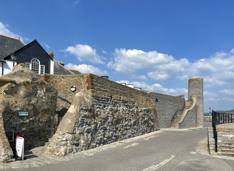
One of the most easterly sea forts in Lyme Regis stood on Gun Cliff throughout
Blake's defence of Lyme in the English Civil War, until early C19.
The walls themselves are of stone rubble laid in regular courses; irregular height;
in places with ledges. One wall extends north from Cobb Gate Jetty, eastwards
round rear of Nos 1 and 2 Broad Street and northwards again as far as the Buddle
Bridge; another wall returns southward from the other side of the Bridge and
then eastwards round Gun Cliff; it then returns north following a curve in the
land and then eastward as far as the jetty at the east end of the Marine Theatre.
Craftsmen from Lyme Regis were well known in mediaeval and late mediaeval times
for their skill in constructing piers and sea defences; these walls like the
older parts of the walls of the Cobb are an example of this skill [see Gyril
Wanklyn," Lyme Regis: a Retrospect;" see also article in Mariners' Mirror for
October 1934 and various maps and manuscripts in Manuscrips Room, British Museum.]
From the sea, the sea walls at Gun cliff form a group with the faces of the Museum
and Guildhall & with the rear faces of Nos 1 & 2 Broad Street.
Listing NGR: SY3429692090
External links are from the relevant listing authority and, where applicable, Wikidata. Wikidata IDs may be related buildings as well as this specific building. If you want to add or update a link, you will need to do so by editing the Wikidata entry.


Other nearby listed buildings
