Approximate Location Map
Large Map »
Latitude: 50.7338 / 50°44'1"N
Longitude: -1.7739 / 1°46'26"W
OS Eastings: 416050
OS Northings: 92706
OS Grid: SZ160927
Mapcode National: GBR 55B.VQQ
Mapcode Global: FRA 7754.NQ0
Plus Code: 9C2WP6MG+GC
Entry Name: The Constable's House
Listing Date: 14 October 1953
Grade: I
Source: Historic England
Source ID: 1325069
English Heritage Legacy ID: 101453
ID on this website: 101325069
Location: Christchurch, Bournemouth, Christchurch and Poole, Dorset, BH23
County: Bournemouth, Christchurch and Poole
Parish: Christchurch
Built-Up Area: Christchurch
Traditional County: Hampshire
Lieutenancy Area (Ceremonial County): Dorset
Church of England Parish: Christchurch Holy Trinity
Church of England Diocese: Winchester
Tagged with: Building
CASTLE STREET
1. (South Side)
5187
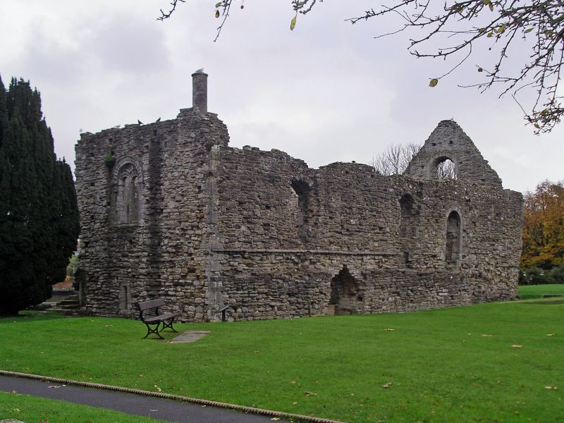
The Constable's House
SZ 1592 1A/18 14.10.53.
I GV
2.
C12. Built by Baldwin de Redvers in the north-east angle of the curtain wall of
the Castle. A 2 storey, rectangular building of stone rubble. Almost all the
walls survive with the southern gable end. Round arched window openings in all
4 facades, divided into 2 lights by a shaft of Purbeck marble. Arches have
chevron moulding. Slits on ground floor. In the centre of the east wall is an
original circular chimney shaft. (NMR).
Nos 1 to 11 (odd), the Castle, the signboard of the King,s Arms Hotel the
Constable's House and the Town Bridge, form a group with Nos 4 to 6 (even).
6A, 8 to 12 (even), 12A, 14 to 18 (even) and the King's Arms Hotel opposite.
Nos 10, 12 and 12A form part of a group on Millham Street and Nos 8 and 10
are buildings of local interest.
Listing NGR: SZ1605092706
External links are from the relevant listing authority and, where applicable, Wikidata. Wikidata IDs may be related buildings as well as this specific building. If you want to add or update a link, you will need to do so by editing the Wikidata entry.


Other nearby listed buildings
